
Severe Weather Awareness 2026: Flooding

The Southern Tennessee Weather Blog is proudly presented by Heritage South Community Credit Union.
We Help When Others Won’t!
Visit https://www.heritagesouth.org/ today to see how HSCCU can help YOU!
Southern Middle Tennessee is settling into a stretch of warm, spring-like weather as we begin the new work week. High pressure is firmly in control today, bringing sunny skies and highs climbing into the lower to mid-60s. That warm trend continues through midweek as winds turn southerly and temperatures push into the upper 60s and lower 70s Tuesday and Wednesday.
Dry conditions hold through at least Wednesday, though clouds will gradually increase as we move closer to the end of the week. By Thursday into Friday, a cold front approaches from the west, bringing increasing humidity, stronger winds aloft, and low to medium rain chances. While widespread severe weather is not expected locally at this time, a few storms Thursday afternoon or evening could produce gusty winds. After the front moves through, temperatures trend back closer to normal heading into the weekend.
Now that we’re done with the forecast, it’s time for today’s Severe Weather Awareness topic: FLOODING, one of the most common and dangerous weather hazards we face here in Southern Middle Tennessee. Over the next 5 days, each blog post will focus on a different severe weather topic for our area.
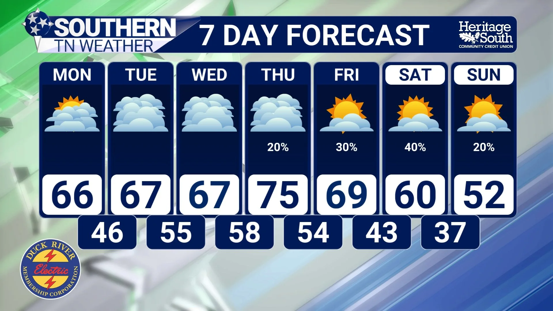
STNWX 7-DAY FORECAST
Why Flooding Is a Serious Threat in Our Area
Flooding is the leading cause of weather-related fatalities in the United States, and it does not take a major storm to create dangerous conditions. Our region is especially vulnerable due to a combination of rolling terrain, creeks and rivers that respond quickly to heavy rain, and areas with poor drainage.
Flooding can occur in several ways:
Flash flooding, which happens rapidly after heavy rainfall
River flooding, when prolonged rain causes rivers and streams to rise
Urban flooding, where storm drains are overwhelmed
Rural flooding, where water spreads across fields, low-lying roads, and creek bottoms
Many flooding fatalities occur not inside homes, but on roads.
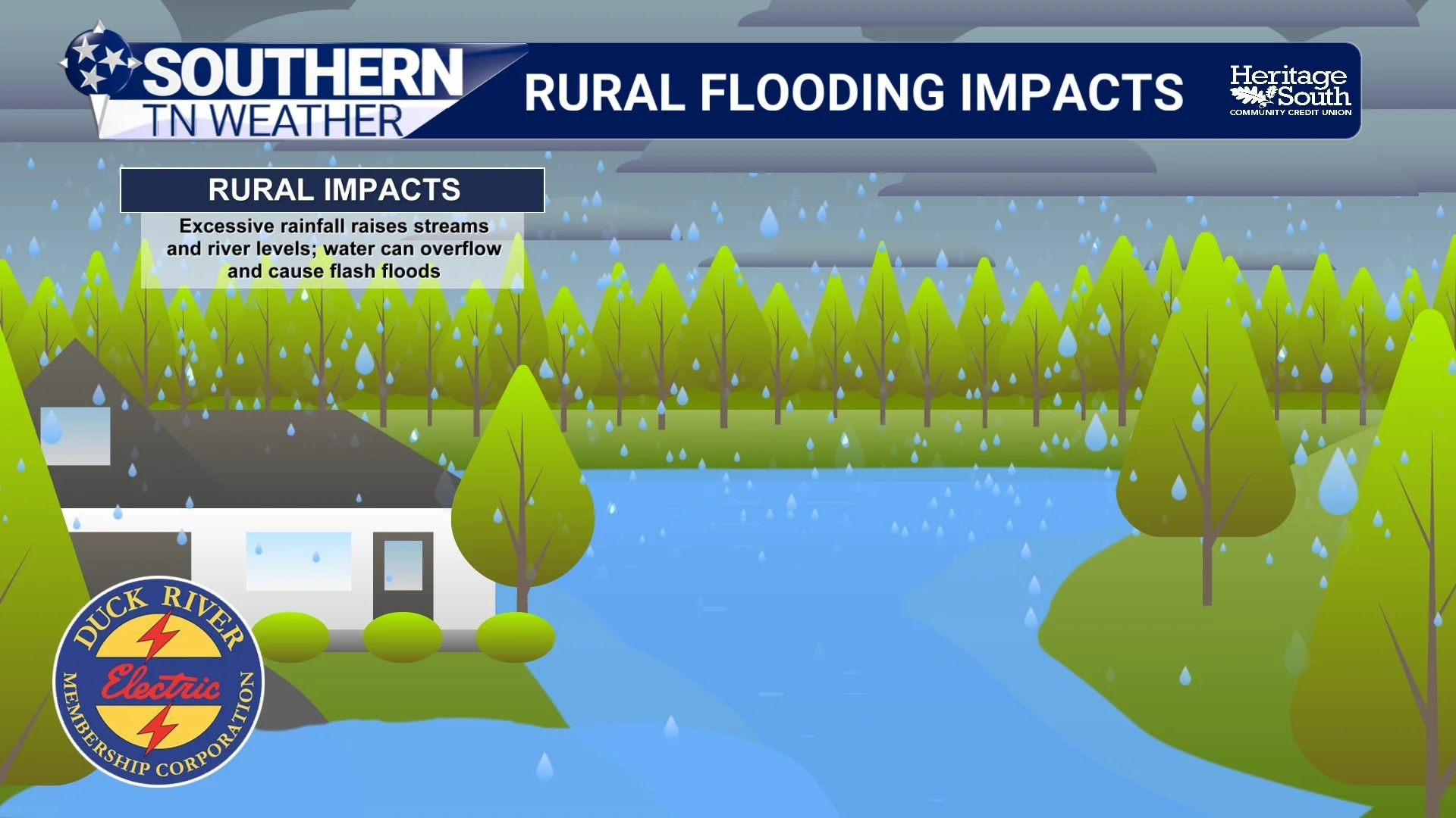
Rural vs. Urban Flooding Impacts
In rural areas, excessive rainfall can cause creeks and rivers to rise quickly, often overtopping banks with little warning. Low-water crossings, hollows, and gravel roads are especially dangerous. Water may look shallow but can be fast-moving and powerful enough to sweep away vehicles.
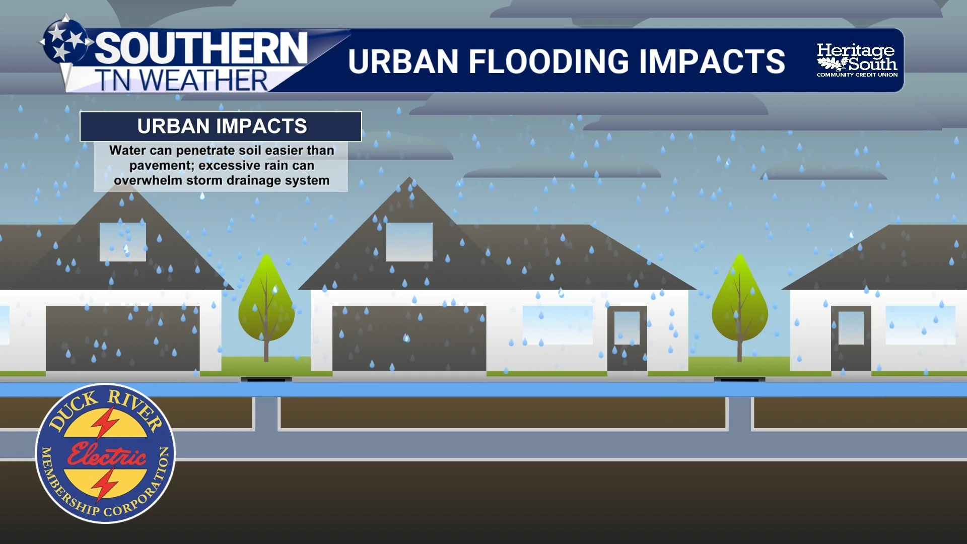
In urban and suburban areas, flooding happens differently. Pavement prevents water from soaking into the ground, forcing rainfall into storm drains. When rain falls faster than those drains can handle, water backs up into streets, intersections, parking lots, and neighborhoods. This is why flooding can occur even when rivers are not out of their banks.
RURAL FLOODING IMPACTS
URBAN FLOODING IMPACTS
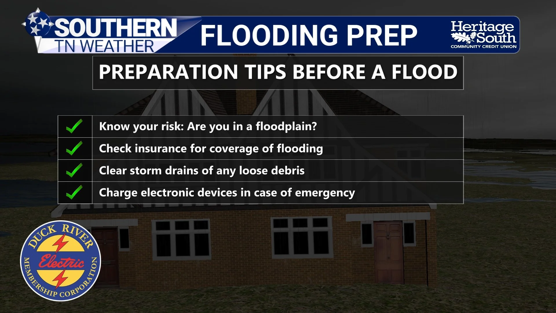
Flood Preparation: What to Do Before Heavy Rain Arrives
Knowing your risk ahead of time is critical. If you live near a creek, river, or low-lying area, flooding can happen quickly. Before heavy rain:
Know whether your home or daily travel routes are in flood-prone areas
Check that storm drains and ditches near your home are clear of debris
Review your insurance coverage. Flood damage is not covered by standard homeowners insurance
Charge phones and electronic devices in case of power outages
Have multiple ways to receive weather warnings, especially overnight
Preparation is about reducing surprises and giving yourself time to act!
FLOODING PREPARATION
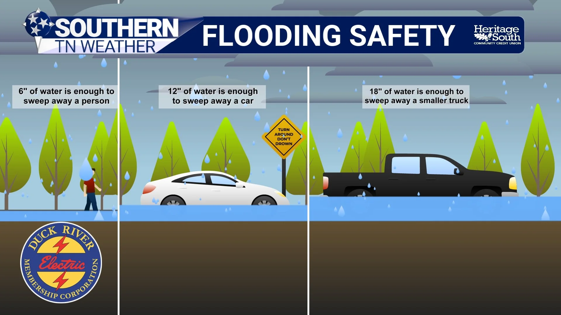
Flood Safety: Why “Turn Around, Don’t Drown” Matters
It takes far less water than most people realize to become life-threatening:
6 inches of moving water can knock a person off their feet
12 inches of water can carry away a car
18 inches of water can sweep away trucks and SUVs
You cannot see the road beneath floodwater, and you cannot judge the strength of the current. Most flood deaths happen when people attempt to drive through water-covered roads.
If you encounter a flooded roadway:
Turn around and find another route
Do not drive around barricades
Do not walk through moving water
Move to higher ground if water is rising
Floodwaters may also contain debris, contaminants, or downed power lines.
FLOOD SAFETY
The Bottom Line 🧾
• Flooding is the most common and deadly severe weather hazard
• It does not take a severe storm to create dangerous flooding
• Rural and urban areas flood in different ways, but both are dangerous
• Just a small amount of moving water can be life-threatening
• Never drive through flooded roads. Turn Around, Don’t Drown
• Preparation and awareness save lives
📰 This week is Tennessee Severe Weather Awareness Week. Each day, we will focus on a different hazard that impacts Southern Middle Tennessee, with practical information to help you stay prepared and informed. The Southern Tennessee Weather Blog, presented by Heritage South Community Credit Union, is updated daily with local forecasts and safety information you can trust.