
From Record Heat to a Chilly Autumn Weekend: The Coldest Weather of the Season (So Far) Is Here!

The Southern Tennessee Weather Blog is proudly presented by Heritage South Community Credit Union.
We Help When Others Won’t!
Visit https://www.heritagesouth.org/ today to see how HSCCU can help YOU!
Well, folks, I think we can officially say that summer has been EVICTED from Southern Middle Tennessee... at least for a little while! 😂 After spending much of this week dealing with record-breaking October heat and temperatures approaching 90 degrees, our strongest cold front of the fall season so far is moving through the region today. And boy, is it bringing quite the change!
We're going from afternoons in the upper 80s and lower 90s to temperatures struggling to climb out of the 50s and lower 60s on Saturday. Throw in gusty northerly winds, plenty of cloud cover today, and the potential for our FIRST FROST of the season Sunday morning, and we've got ourselves a pretty impressive autumn cooldown! The good news is that the weekend looks largely dry, with improving sunshine and some beautiful fall weather expected by Sunday. The bad news? Our ongoing drought isn't going to get much help from this cold front. While a few sprinkles and light showers will be possible today, rainfall totals will be extremely limited, and another extended stretch of dry weather is expected next week.
Let's break down what to expect over the next several days, including just how cold temperatures could get, where frost may develop, and what this means for your weekend plans across Southern Middle Tennessee.
Friday: A Cold Front, Falling Temperatures and Gusty Winds
Our strong cold front is pushing through Southern Middle Tennessee today, bringing a noticeable change in conditions compared to what we've experienced throughout the workweek. Temperatures likely reached their highest levels during the late morning or early afternoon in many communities, with readings expected to fall through the remainder of the day as colder air pours into the region. This is a little unusual compared to a typical October afternoon, when temperatures generally reach their highest levels during the middle or latter part of the afternoon. Instead, we're dealing with a steady influx of colder air behind the front, which means temperatures may actually be LOWER at 4 PM than they were around lunchtime!
Cloud cover is another big part of today's forecast. While some communities started the morning with sunshine, widespread clouds are developing behind the cold front, creating a rather gloomy appearance across much of the region. A few sprinkles and light rain showers will also be possible through the afternoon and evening, particularly as additional moisture and atmospheric lift move across the area. However, don't expect much in the rainfall department. Most locations will receive little more than a trace, with any measurable totals generally limited to a few hundredths of an inch. Unfortunately, that's not going to provide meaningful relief from our ongoing drought.
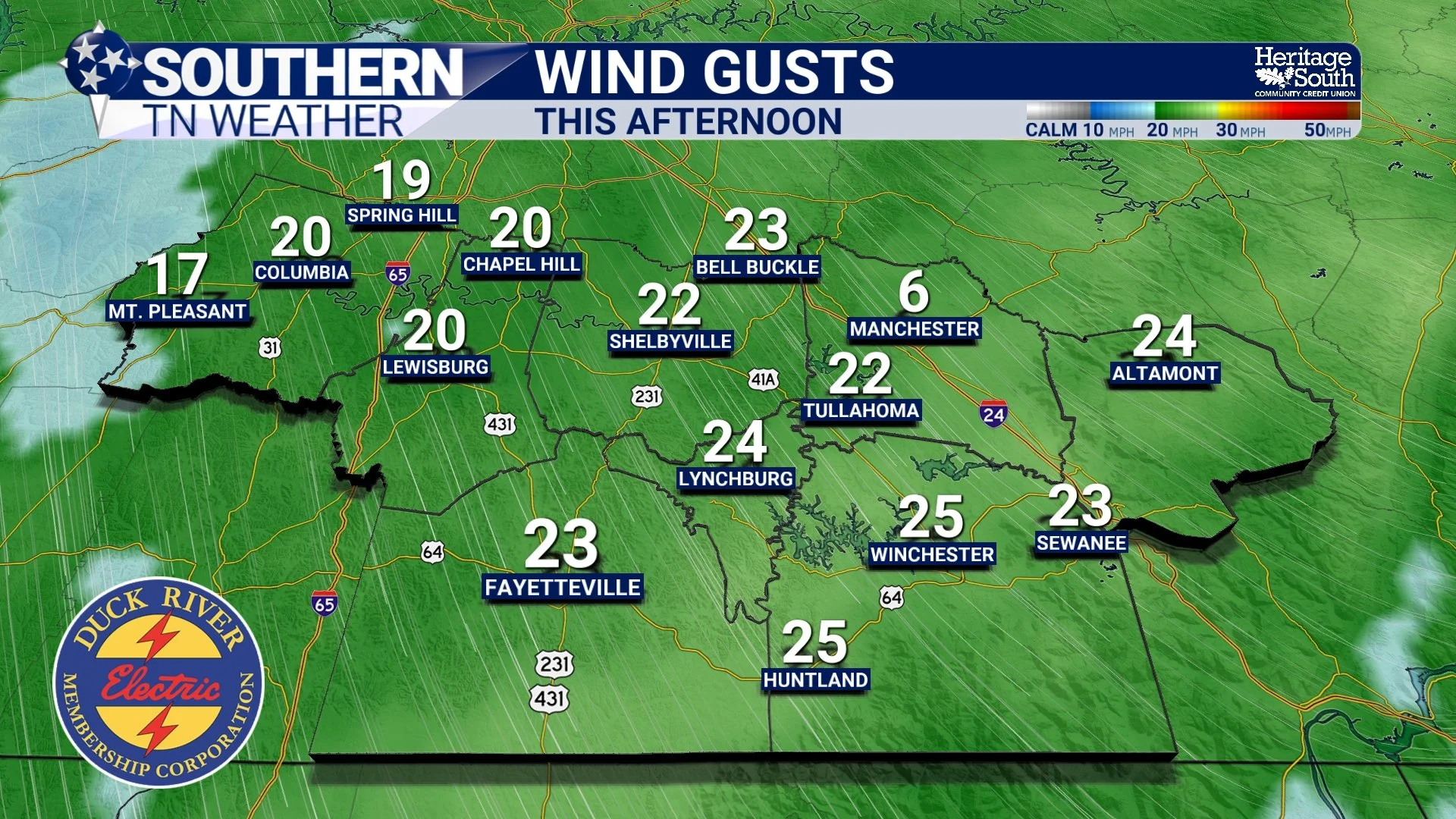
The other big story today is the WIND. Northwest winds will increase to around 10–20 MPH, with gusts frequently reaching 20–30 MPH in some locations. Those winds will help transport the colder air into Southern Middle Tennessee, making conditions feel increasingly chilly as the afternoon progresses. By this evening, temperatures should be falling into the 50s, eventually reaching the 40s overnight. Combined with continued breezy conditions, it's going to feel considerably different from the warm evenings we've experienced recently.
If you've got outdoor plans tonight, especially high school football games or other Friday evening activities, I'd strongly recommend bringing a jacket. Between the gusty winds, falling temperatures and lingering cloud cover, it's going to have a rather raw autumn feel. And yes, I think we can safely retire the shorts and flip-flops for at least a couple of days!
Saturday: Our Coldest Afternoon of the Season So Far!
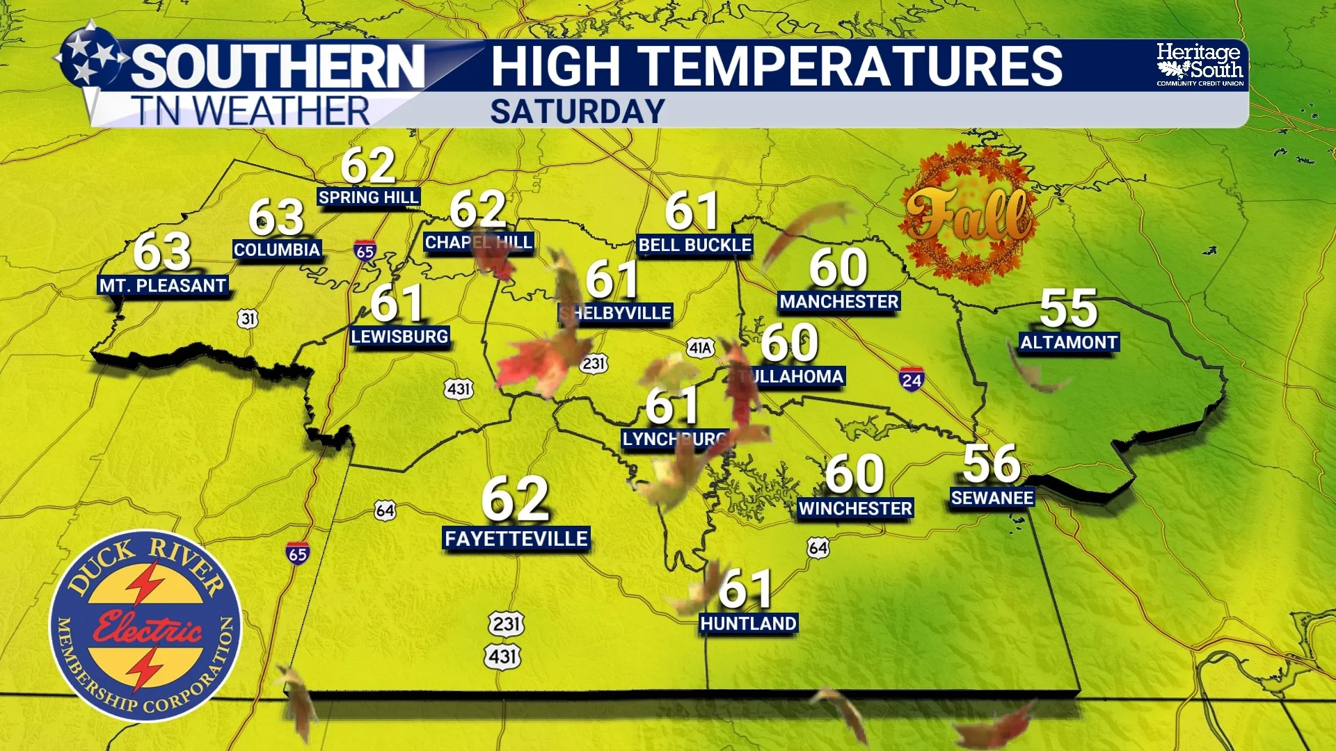
Saturday is shaping up to be the COLDEST afternoon we've experienced so far this fall, and it's going to be a pretty dramatic difference compared to the record-breaking warmth earlier this week. High temperatures are expected to reach only the middle 50s to lower 60s across Southern Middle Tennessee, with some of our higher-elevation communities along the Cumberland Plateau potentially remaining in the 50s throughout the day. That's roughly 25–30 degrees cooler than the temperatures we experienced just a couple of days ago! Despite the chilly temperatures, Saturday won't necessarily be a gloomy day. Skies should gradually become partly to mostly sunny as the cloud cover associated with Friday's cold front moves away. However, the sunshine won't be particularly effective at warming us up because a much colder air mass will be firmly established across the region.
Northerly winds will also remain rather breezy, generally around 10–20 MPH with occasional higher gusts, particularly during the morning and early afternoon. That will add an extra chill to the air, especially in exposed areas where there's little protection from the wind. For anyone attending the Bell Buckle Craft Fair this weekend, Saturday will certainly feel like an authentic autumn day! We're talking about jacket weather for much of the morning and afternoon, with temperatures remaining relatively cool even during the warmest part of the day.
The good news is that widespread rainfall isn't expected, so outdoor events should generally remain dry. Just be prepared for the chilly temperatures and breezy conditions, especially if you're planning to spend several hours outside. One additional concern Saturday will be the combination of dry vegetation, low relative humidity and gusty winds. With our ongoing drought, these conditions could increase the potential for outdoor fires to spread more easily. Relative humidity values may fall toward 30% in portions of Middle Tennessee, and the National Weather Service is encouraging people to avoid outdoor burning.
So, while the cooler temperatures might make a backyard fire sound appealing, I'd strongly recommend holding off until conditions become more favorable.
Sunday Morning: Our First Frost of the Season?
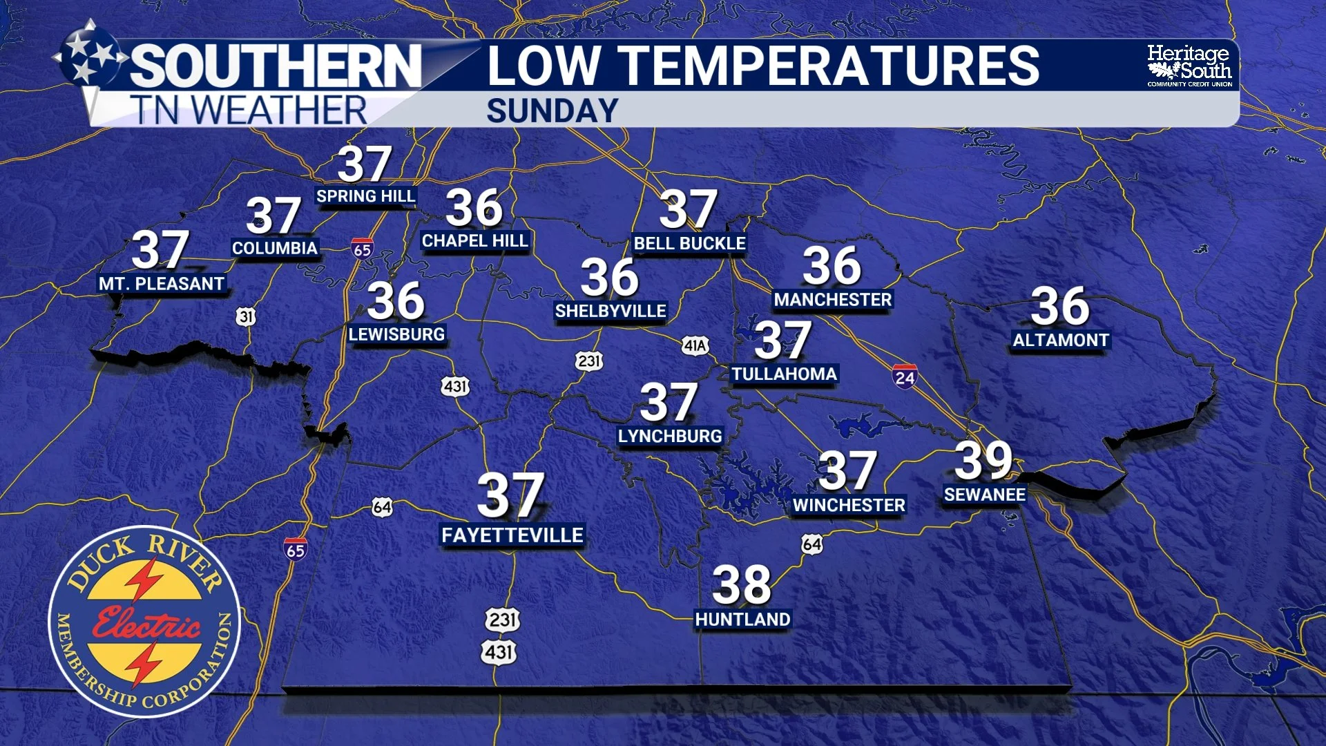
Now, here's where things get particularly interesting. As we move into Saturday night and early Sunday morning, high pressure will begin settling into the region, allowing winds to gradually decrease. Combined with clearing skies and a much colder air mass already in place, this will create favorable conditions for significant nighttime cooling. Overnight temperatures are expected to fall into the 30s across portions of Southern Middle Tennessee, with many other communities dropping into the lower 40s. Some of our traditionally colder valleys, sheltered hollows and portions of the Cumberland Plateau could experience temperatures in the middle 30s, which would be cold enough to support the development of frost.
This doesn't necessarily mean EVERYBODY is going to wake up to frost Sunday morning. Frost development will depend heavily on local temperatures, wind speeds, cloud cover and terrain. Some communities may remain several degrees warmer than others, especially near larger bodies of water or in locations where winds remain elevated overnight. However, if you live in one of our colder valleys or sheltered rural communities, this is certainly something worth paying attention to.
And remember, frost can develop even when the official air temperature remains slightly above freezing. That's because exposed surfaces such as grass, leaves and vehicles can cool several degrees below the surrounding air on clear, calm nights. So, a forecast low of 35 or 36 degrees doesn't necessarily eliminate the possibility of frost. If you've still got sensitive plants or garden vegetables outside, I'd recommend taking some precautions Saturday evening, particularly if you live in a frost-prone location. Covering vulnerable vegetation with frost cloths or bringing potted plants indoors can help prevent damage. At this point, we're primarily concerned about light or patchy frost rather than a widespread hard freeze. However, the exact temperatures will become clearer as we get closer to Sunday morning.
Sunday Afternoon: Beautiful Autumn Weather Returns!
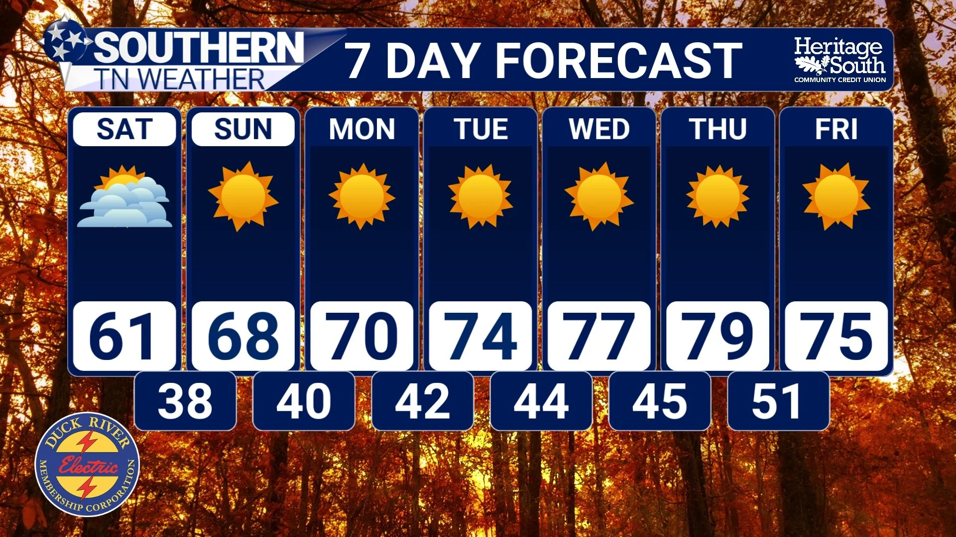
After a rather chilly start to the morning, Sunday is shaping up to be a BEAUTIFUL fall day across Southern Middle Tennessee! High pressure will remain in control of our weather, providing plenty of sunshine, lighter winds and gradually moderating temperatures. Afternoon highs should recover into the middle and upper 60s, with some communities potentially reaching the lower 70s. That's still a little cooler than normal for the middle of October, but compared to Saturday's blustery conditions, Sunday should feel considerably more comfortable.
The biggest difference will be the wind. While Saturday will feature gusty northerly winds, Sunday should be much calmer as the pressure gradient relaxes and high pressure becomes more firmly established across the region. That will make outdoor activities much more enjoyable, especially during the afternoon when temperatures begin climbing. For anyone planning to visit the Bell Buckle Craft Fair, Sunday is looking like an EXCELLENT day to get outside and enjoy some fall festivities. You'll probably want a jacket if you're heading out early in the morning, but by the afternoon, conditions should be quite pleasant with sunshine and temperatures approaching 70 degrees. And honestly, after the record-breaking heat we experienced earlier this week, I think most of us are going to appreciate a weekend that actually FEELS like October!
Next Week: A Gradual Warmup, But Still No Rain
If you're wondering whether this weekend's chilly weather is here to stay, the answer is probably not. High pressure will continue influencing our weather pattern through much of next week, allowing temperatures to gradually moderate as winds become more easterly and eventually southerly. Afternoon highs should return to the upper 60s and lower 70s by Monday, with temperatures gradually climbing through the 70s as the week progresses. By Wednesday and Thursday, some communities may once again reach the upper 70s or even lower 80s, although we aren't currently expecting a return to the widespread record-breaking heat that dominated much of this week.
Overnight temperatures will also become progressively milder, generally returning to the 40s and eventually lower 50s as the cooler air mass begins modifying. Unfortunately, there are no significant rainfall opportunities currently showing up through the middle or latter part of next week. The overall weather pattern looks dominated by high pressure, which will keep skies mostly sunny and conditions predominantly dry. That's great news if you're planning outdoor activities, but not particularly encouraging for our drought situation.
The Bottom Line 🧾
🌬️ Friday: Our strongest cold front of the fall season so far is moving through Southern Middle Tennessee, bringing gusty northwest winds, increasing clouds and falling temperatures.
🌧️ A few sprinkles and light showers are possible Friday afternoon and evening, but rainfall totals should generally remain between a trace and a few hundredths of an inch.
💨 Northwest winds may gust to 20–30 MPH Friday afternoon and evening, adding an extra chill to the air.
🥶 Saturday: The coldest afternoon of the season so far! High temperatures will generally only reach the middle 50s to lower 60s, with breezy northerly winds continuing.
☀️ Saturday should remain mostly dry, with some sunshine returning as the day progresses.
🔥 Dry vegetation, low humidity and gusty winds will increase fire-weather concerns Saturday. Avoid outdoor burning.
❄️ Sunday Morning: Our first light frost of the season is possible, especially across the Cumberland Plateau and traditionally colder valleys and hollows.
🌡️ Overnight lows could fall into the middle and upper 30s in colder locations, with many other communities remaining in the lower 40s.
🍂 Sunday Afternoon: Beautiful fall weather! Mostly sunny skies, lighter winds and highs in the middle and upper 60s to around 70 degrees.
🎪 Bell Buckle Craft Fair: Saturday will be chilly and breezy, while Sunday looks considerably more comfortable for outdoor activities.
🌵 Our ongoing drought remains a concern, with no significant rainfall opportunities expected through at least the middle of next week.
🌤️ Next Week: A gradual warming trend returns, with highs climbing back into the 70s and potentially lower 80s by the middle or latter part of the week.
📰 Reminder: The Southern Tennessee Weather Blog, presented by Heritage South Community Credit Union, is updated Monday through Friday with fresh, locally tailored forecasts you can trust.
