
Latest Drought Monitor: Very Little Improvement, With No Real Relief in Sight

The Southern Tennessee Weather Blog is proudly presented by Heritage South Community Credit Union.
We Help When Others Won’t!
Visit https://www.heritagesouth.org/ today to see how HSCCU can help YOU!
Well, folks, we've got another Thursday, which means another update to the U.S. Drought Monitor. After the widespread rainfall associated with Hurricane Isaias last weekend, I was hoping we'd see at least a little improvement in the drought conditions across Southern Middle Tennessee. And the good news is that we DID see some localized improvement! However, before anybody gets too excited, the overall drought situation hasn't changed very much across our coverage area, and unfortunately, the weather pattern ahead isn't looking particularly encouraging.
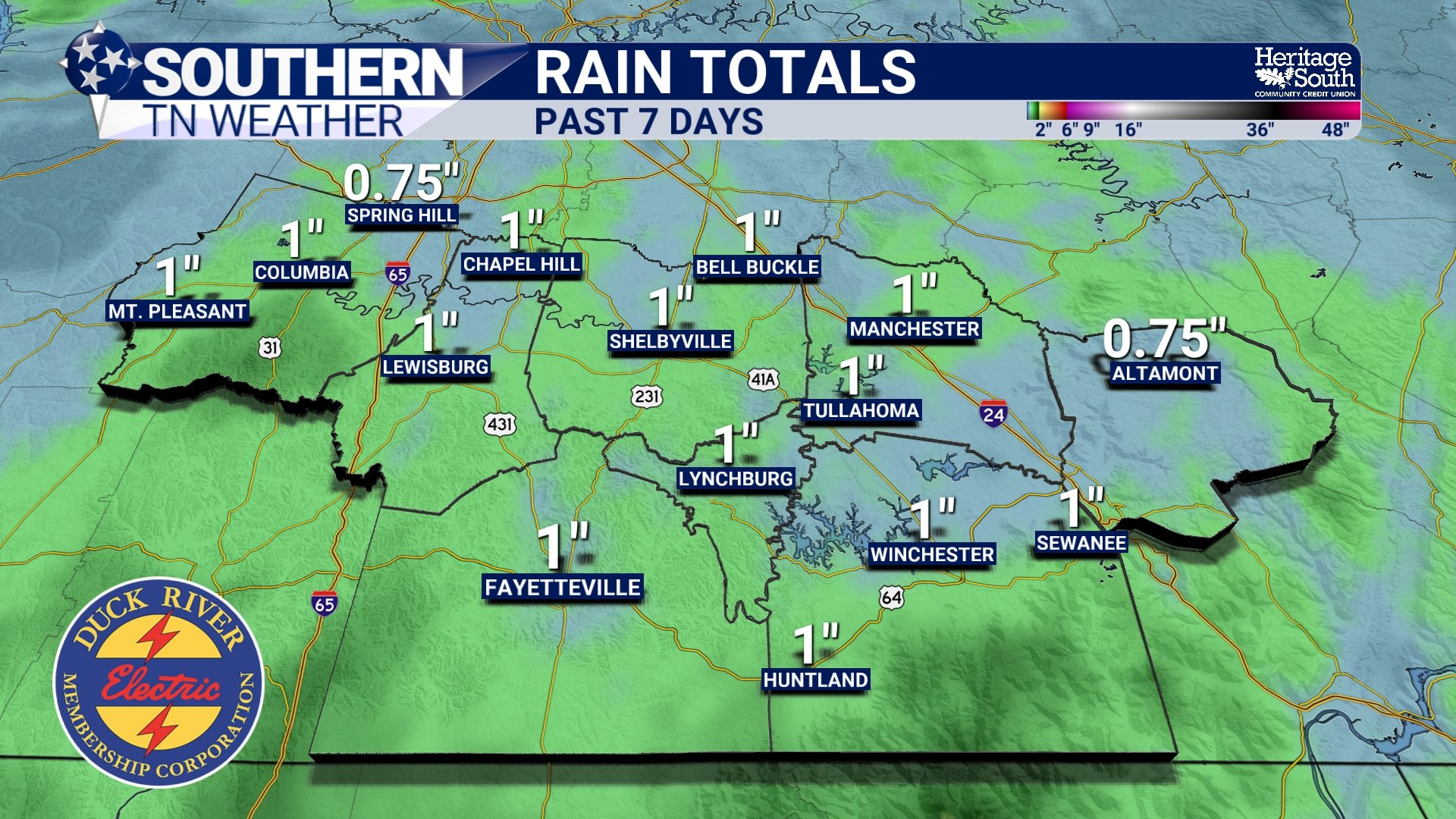
Much of Southern Middle Tennessee remains in Moderate to Severe Drought, with pockets of Extreme Drought still showing up across portions of the region. While last weekend's rainfall was certainly beneficial, it wasn't nearly enough to erase the significant precipitation deficits that have accumulated over the past several weeks and months. Some locations received around an inch of rainfall, which helped put a little moisture back into the ground, but one decent rain event simply can't undo the effects of a prolonged dry spell.
And here's the frustrating part: we've got a strong cold front arriving Friday, but it's looking increasingly likely to move through with little, if any, meaningful rainfall. After that, the forecast remains dry well into next week. So, while we may finally get a break from the record-breaking October heat, we're not getting the widespread soaking rainfall that we desperately need.
What Changed on This Week's Drought Monitor?
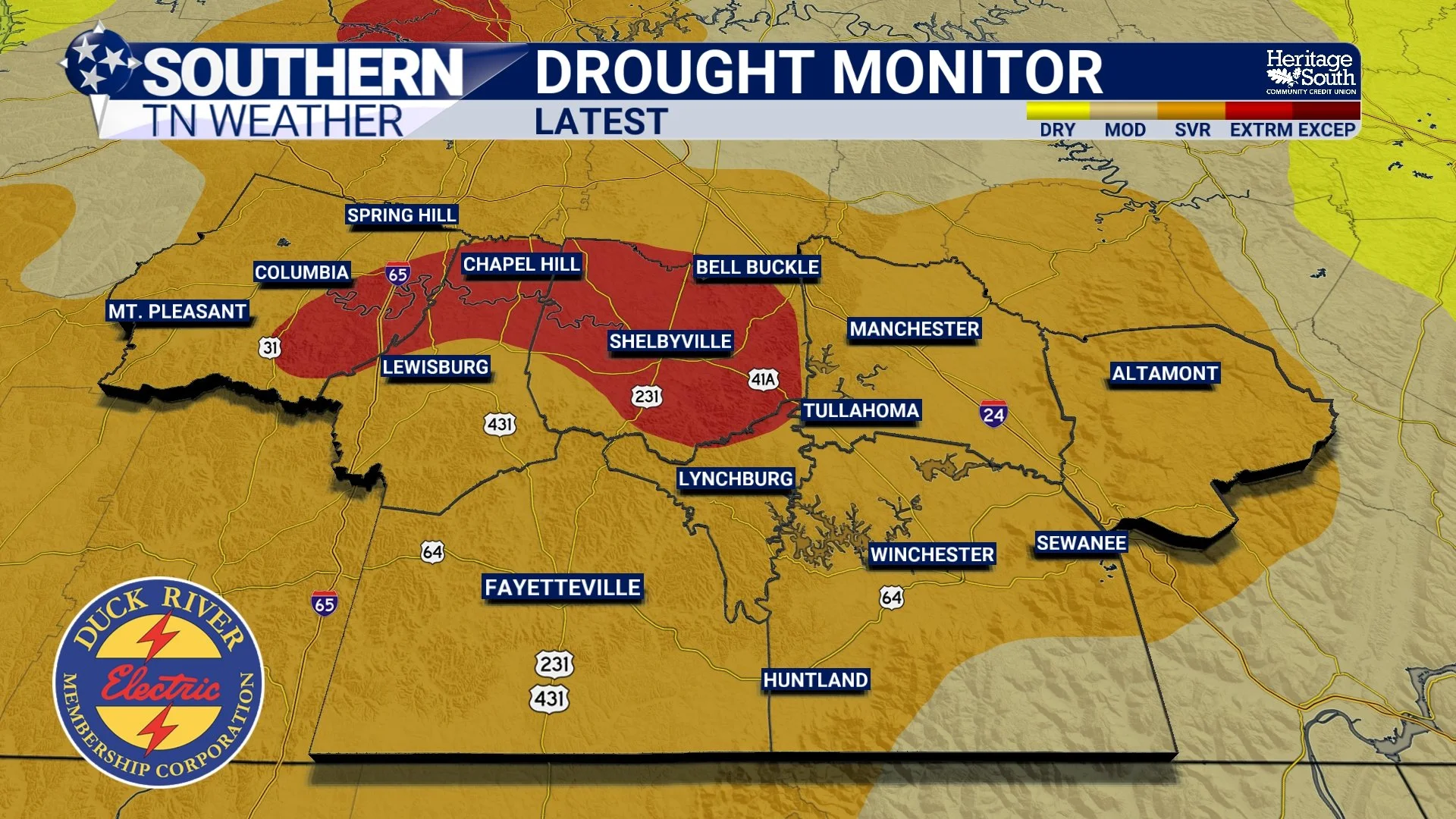
Looking at the latest U.S. Drought Monitor map, the biggest takeaway for Southern Middle Tennessee is that there hasn't been a dramatic change in our overall drought conditions compared to last week. Some localized improvements were made across Tennessee following the rainfall associated with Hurricane Isaias, but significant drought conditions remain firmly established across much of our region. The latest map continues to show a broad area of drought across western and central Tennessee, with the most significant drought conditions concentrated in several pockets farther west and across portions of Middle Tennessee.
The map shows Moderate Drought (D1) extending across portions of northern and eastern Middle Tennessee, while Severe Drought (D2) remains widespread across many southern and western communities. Pockets of Extreme Drought (D3) are still present, including areas associated with the upper Duck River Basin. These are the same general areas we've been watching closely in recent weeks, where rainfall deficits and depleted soil moisture have been especially persistent.
For communities around Columbia, Lewisburg, Shelbyville, Lynchburg, Manchester and Tullahoma, the overall message hasn't changed substantially. While conditions vary from one community to another, drought remains an ongoing concern, and the recent rainfall hasn't been enough to bring widespread recovery. The latest regional drought discussion specifically mentions localized improvements in Tennessee and Mississippi associated with rainfall from Hurricane Isaias. That's encouraging, but the improvements were limited rather than widespread. Some locations received enough rain to support a reduction in drought severity, while others remained in essentially the same category as last week.
It's also important to understand that the Drought Monitor isn't simply a map of how much rain fell over the past seven days. It incorporates a variety of indicators, including precipitation deficits over different time periods, soil moisture, streamflow and other measures of drought severity. That means a location can receive beneficial rainfall without immediately seeing its drought classification improve. In other words, just because the grass looks a little greener doesn't necessarily mean the drought is over!
Why Didn't Hurricane Isaias Fix the Drought?
This is probably one of the biggest questions I've seen following last weekend's rainfall. We had a tropical system move through the region, many communities received a decent soaking, and yet we're still dealing with substantial drought conditions. So, what gives? The answer comes down to the difference between short-term rainfall and longer-term moisture deficits. During September, much of Southern Middle Tennessee experienced unusually hot and dry weather. In fact, according to the National Centers for Environmental Information, Tennessee recorded its second-warmest September in 132 years of records. That kind of persistent warmth increases the atmosphere's demand for moisture, especially when accompanied by extended periods of sunshine and little rainfall.
As temperatures climb, evaporation from exposed soil and water surfaces generally increases, while vegetation can lose additional moisture through transpiration. When rainfall remains limited for several weeks, soil moisture gradually declines, streamflows can fall, and agricultural conditions begin to deteriorate. By the time Hurricane Isaias arrived, we were already dealing with substantial accumulated rainfall deficits. While the storm delivered beneficial moisture to portions of Southern Middle Tennessee, many locations received rainfall totals near the lower end of our original forecast range. That was enough to temporarily improve surface moisture and help some vegetation recover, but it wasn't necessarily enough to replenish deeper soil moisture or eliminate the longer-term deficits.
There's also a major difference between rainfall soaking into the upper few inches of soil and moisture reaching deeper layers or contributing to sustained streamflow recovery. Depending on rainfall intensity, soil conditions and terrain, some water may run off before it has an opportunity to penetrate deeply into the ground. That doesn't mean the rainfall was wasted. Far from it! Every beneficial soaking rain helps, especially when it falls at a manageable rate. However, drought recovery usually requires repeated rainfall events over an extended period, rather than one isolated soaking.
Think of it like trying to refill a bathtub that's been draining for weeks. Pouring in one bucket of water certainly helps, but you're going to need quite a few more buckets before it's full again. And right now, Mother Nature doesn't seem particularly interested in delivering those additional buckets.
Drought Conditions Are Getting Worse Across Parts of the South
While Southern Middle Tennessee saw relatively limited changes this week, the broader drought situation across the southern United States continues to be concerning. According to the latest U.S. Drought Monitor discussion, drought conditions were mixed across the South, with localized improvements in portions of Texas, Mississippi and Tennessee. However, widespread deterioration continued across the lower Mississippi Valley, where persistent rainfall deficits, unusually warm temperatures and elevated evaporative demand contributed to further drying.
Some of the most significant deterioration occurred from eastern Texas and southern Louisiana northward through central Mississippi, Arkansas and west-central Tennessee. Across portions of Arkansas and northern Louisiana, the most severe drought classification, Exceptional Drought (D4), expanded as soil moisture continued to decline. The regional discussion also highlights just how extraordinary September's warmth was. Texas, Oklahoma, Arkansas and Louisiana all experienced their warmest September in 132 years of records, while Tennessee recorded its second-warmest September and Mississippi its third-warmest.
That's a pretty remarkable stretch of heat across a large portion of the southern United States, and it helps explain why drought conditions have been so persistent. When temperatures remain significantly above normal for extended periods, the atmosphere can demand more moisture from soils and vegetation, making existing drought conditions harder to overcome. The regional impacts of Hurricane Isaias were also uneven. While portions of Tennessee and Mississippi received beneficial rainfall, much of the lower Mississippi Valley missed out on meaningful precipitation from the storm. As a result, drought conditions continued deteriorating across several areas even while localized improvements occurred elsewhere.
This is an important reminder that drought conditions can vary considerably across relatively short distances. One community might receive enough rainfall to see modest improvement, while another location only a few counties away continues getting progressively drier.
A Strong Cold Front Is Coming Friday... But Don't Expect Much Rain
Now, here's where our forecast becomes particularly frustrating. We've spent much of this week dealing with temperatures in the upper 80s and lower 90s, with record-breaking warmth occurring across portions of the region. For the middle of October, that's pretty remarkable! Thankfully, a strong cold front will finally sweep through Southern Middle Tennessee on Friday, bringing a significant change in our temperatures.
Unfortunately, the front is expected to be moisture-starved, meaning there simply won't be enough atmospheric moisture available to support widespread rainfall. The main area of low pressure and stronger atmospheric forcing will remain well to our north and northeast, while drier air begins moving into the region from the west.
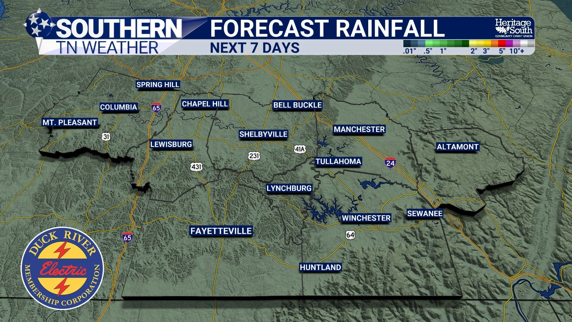
Rain chances are VERY low for tomorrow, and any rainfall that does occur is expected to be minimal. The Huntsville forecast office does mention the possibility of a few light showers, particularly along and east of Interstate 65 Friday afternoon, but widespread measurable rainfall isn't expected. So, while Friday's cold front will be strong enough to produce a dramatic temperature drop and gusty northerly winds, it won't do much to help our drought situation.
In fact, the National Weather Service in Nashville specifically notes that drought conditions are expected to worsen in the near term, with no additional rain-producing systems currently expected after Friday. That's not exactly the forecast we were hoping for…
Could the Cooler Weather at Least Help Slow the Drought?
There is one small silver lining to our approaching cold front: the much cooler temperatures expected this weekend should help reduce evaporative demand compared to the unusually hot conditions we've experienced this week. When temperatures are in the upper 80s and lower 90s, especially with plenty of sunshine, moisture can be lost from soils and vegetation relatively quickly. As temperatures fall into the 60s, the atmosphere generally has less capacity to hold water vapor, and evaporative demand often decreases.
However, temperature isn't the only factor involved. Humidity, wind speeds, sunshine and soil moisture all influence how quickly water evaporates. Friday and Saturday are expected to be rather breezy, and the incoming air mass will also be much drier. Those conditions can still promote some moisture loss, even with substantially cooler temperatures. So, while the cooler weather may provide some relief from the extreme warmth we've been experiencing, it won't actually replenish the moisture that's already missing.
And once temperatures begin warming again next week, we'll return to a relatively mild and dry pattern with little opportunity for meaningful rainfall. That's why I'm continuing to emphasize the importance of getting multiple soaking rainfall events over the coming weeks. We don't necessarily need a major storm system or flooding rainfall. What we really need is a series of beneficial, manageable rain events that can gradually restore soil moisture and improve streamflow conditions. Unfortunately, we're just not seeing that kind of pattern developing in the immediate forecast.
The Forecast: Record Heat Ends, Chilly Weather Arrives, Then Another Dry Stretch
Let's take a closer look at what we can expect across Southern Middle Tennessee over the next several days, because even though rainfall opportunities are limited, there are some pretty significant temperature changes headed our way.
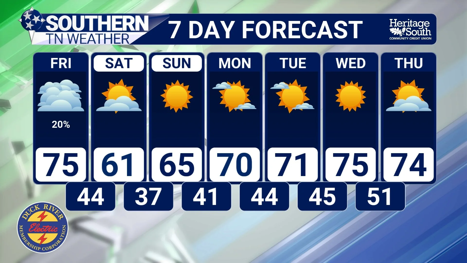
Thursday: One final day of unseasonably warm weather is expected, with high temperatures climbing into the upper 80s and lower 90s. Daily record highs could be challenged or broken across portions of the region, with plenty of sunshine and relatively warm conditions continuing through the afternoon. Overnight temperatures will remain mild ahead of the approaching cold front, generally falling into the lower and middle 60s.
Friday: A strong cold front will sweep through the region, bringing gusty northwesterly winds and noticeably cooler temperatures. Afternoon highs may reach the middle 70s to around 80 degrees in some locations before the colder air becomes firmly established, but temperatures should begin falling throughout the afternoon and evening. Winds could gust over 25 MPH, with some gusts approaching 30 MPH Friday night. A few light showers can't be ruled out, but most locations should remain dry.
Saturday: A much cooler air mass will settle across Southern Middle Tennessee, bringing a genuinely autumn-like feel to the region. High temperatures will generally reach the lower to middle 60s, with some locations perhaps climbing into the upper 60s. Northerly winds of 10–20 MPH will make conditions feel even cooler during the morning and early afternoon, although winds should gradually diminish later in the day. Skies should remain partly to mostly sunny.
Sunday: This could be our coldest morning of the season so far! Overnight temperatures are expected to fall into the upper 30s and lower 40s across much of the region, with some of our colder valleys and portions of the Cumberland Plateau potentially experiencing frost. Afternoon temperatures should recover into the middle and upper 60s to lower 70s under mostly sunny skies.
Monday through Wednesday: High pressure will continue dominating our weather pattern, keeping conditions dry across Southern Middle Tennessee. Temperatures will gradually moderate, with afternoon highs returning to the upper 60s and lower 70s Monday, lower to middle 70s Tuesday, and potentially the middle 70s to around 80 degrees by Wednesday. Overnight lows should generally remain in the 40s and lower 50s.
Unfortunately, there are no significant rainfall opportunities currently showing up through the middle of next week, which means our drought concerns will remain firmly in place.
The Bottom Line 🧾
🌵 The latest U.S. Drought Monitor shows relatively limited changes across Southern Middle Tennessee, with localized improvements following last weekend's rainfall.
🟠 Moderate to Severe Drought remains widespread across much of our region, with pockets of Extreme Drought still present.
🌧️ Hurricane Isaias delivered beneficial rainfall to portions of Tennessee, but the totals weren't enough to eliminate our longer-term moisture deficits.
📉 Drought conditions worsened across much of the lower Mississippi Valley, particularly portions of Arkansas, Louisiana and surrounding states.
🔥 Tennessee experienced its second-warmest September in 132 years of records, contributing to elevated evaporative demand and worsening drought conditions.
🌬️ A strong cold front arrives Friday, bringing gusty winds and a substantial temperature drop.
💧 Unfortunately, Friday's front is expected to produce little, if any, meaningful rainfall across Southern Middle Tennessee.
🥶 Saturday's highs will generally only reach the 60s, with our coldest temperatures of the season possible Sunday morning.
❄️ Frost will be possible Sunday morning, especially across portions of the Cumberland Plateau and our traditionally colder valleys.
☀️ Dry weather is expected to continue through at least the middle of next week, with temperatures gradually warming again.
⚠️ Without additional meaningful rainfall, drought conditions are likely to worsen in the near term.
📰 Reminder: The Southern Tennessee Weather Blog, presented by Heritage South Community Credit Union, is updated Monday through Friday with fresh, locally tailored forecasts you can trust.
