
Rain Returns… A Closer Look at the Next 3 Days

The Southern Tennessee Weather Blog is proudly presented by Heritage South Community Credit Union.
We Help When Others Won’t!
Visit https://www.heritagesouth.org/ today to see how HSCCU can help YOU!
It’s been a quiet, comfortable stretch across Southern Middle Tennessee, but the pattern is about to flip again in a pretty classic late-spring way. A warm, breezy Monday is serving as the transition point between dry air and what will become a multi-day period of rain and embedded storms.
The key thing to understand with this setup is that we are not dealing with one clean, organized storm system. Instead, this is a series of disturbances moving through a very moist atmosphere, interacting with a frontal boundary that will eventually stall somewhere near the region. That combination is what is driving our rain chances over the next 3 days.
THE SETUP: MOISTURE IS THE MAIN PLAYER
Today’s weather may feel fairly typical for early May, but behind the scenes, the atmosphere is already beginning to change. Southerly winds are pulling moisture northward from the Gulf, gradually increasing humidity levels.
Meteorologists often measure this moisture using something called PWAT, or precipitable water. In simple terms, PWAT tells us how much total moisture is available in a column of air above us. By Tuesday night into Wednesday, PWAT values are expected to climb into the 1.5 to 2.0 inch range, which is very high for this time of year. When you combine that kind of moisture with a slow-moving or stalled boundary, it creates an environment where rain can become efficient very quickly. In other words, when it rains, it can pour.
TUESDAY: THE RAIN BEGINS
Rain chances will increase through the day Tuesday as the first disturbance moves in from the northwest. This will not be an immediate washout, especially early in the day, but expect clouds to thicken with scattered showers developing by afternoon and evening.
There may be a few rumbles of thunder, but instability, which is the fuel storms use to grow stronger, will be limited. Instability is often measured using CAPE (Convective Available Potential Energy), and values Tuesday will remain quite low. That keeps the severe weather threat minimal during this phase. By Tuesday night, a frontal boundary will begin to slow down and stall near the region, likely somewhere close to the I-40 corridor. This is where things start to get more interesting from a rainfall standpoint.
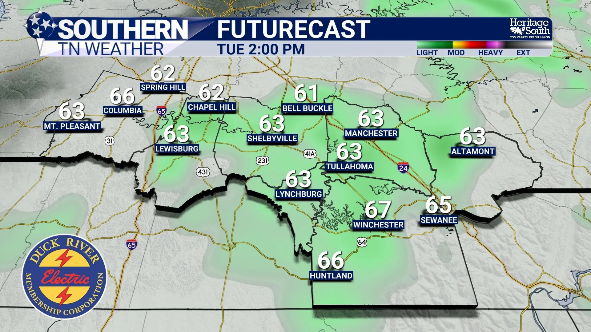
FUTURECAST - TUESDAY AFTERNOON
TUESDAY NIGHT INTO WEDNESDAY: HEAVY RAIN BECOMES THE FOCUS
As we head into Tuesday night and especially Wednesday, multiple waves of energy will move along that stalled boundary. This is important because it allows for repeated rounds of rain over the same areas, a process known as training. Think of it like train cars moving along the same track. Instead of one quick burst of rain, you get multiple rounds passing over the same location. That’s how localized flooding can develop, even if the overall system is not particularly intense.
Rainfall totals across Southern Middle Tennessee will likely add up into the 1.5 to 3 inch range by Wednesday night, with the highest amounts generally favored the further south and east you are. Not everyone will see the exact same totals, but enough rain is expected to at least HELP ease drought conditions. Localized flooding is the main concern here. With soils still relatively dry, widespread flooding is not expected, but low-lying areas, poor drainage spots, and roadways could see water issues, especially during heavier downpours.
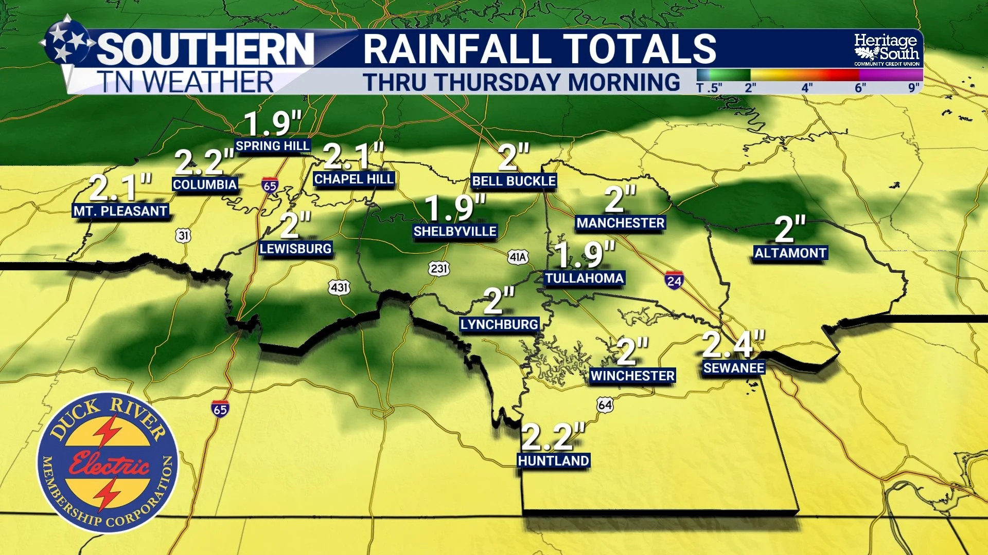
RAINFALL TOTALS - THRU THURSDAY MORNING
WHAT ABOUT SEVERE WEATHER?
The severe weather threat with this system is relatively low compared to what we often see in spring, and there’s a good reason for that. Southern Middle Tennessee will largely sit on the cooler, more stable side of the system, north of the best instability. That limits the ability for storms to become strong or organized.
However, it’s not zero. If we manage to get any breaks in the clouds Wednesday that allow for daytime heating, or if the system tracks slightly farther north, there could be just enough instability to work with. In that case, the atmosphere will already have strong wind shear in place. Wind shear refers to changes in wind speed and direction with height, and it helps storms organize and rotate.
Even modest instability combined with strong shear can occasionally produce stronger storms. The best chance for that would be closer to the Alabama state line, where slightly better instability could develop. Even there, the overall threat remains limited, with damaging winds being the primary concern and only a very low tornado risk. A MARGINAL risk (level 1 out of 5) is in place for the entire area to account for this VERY low-end threat. The main timeframe for any stronger storms would be between noon and 9 PM on Wednesday.
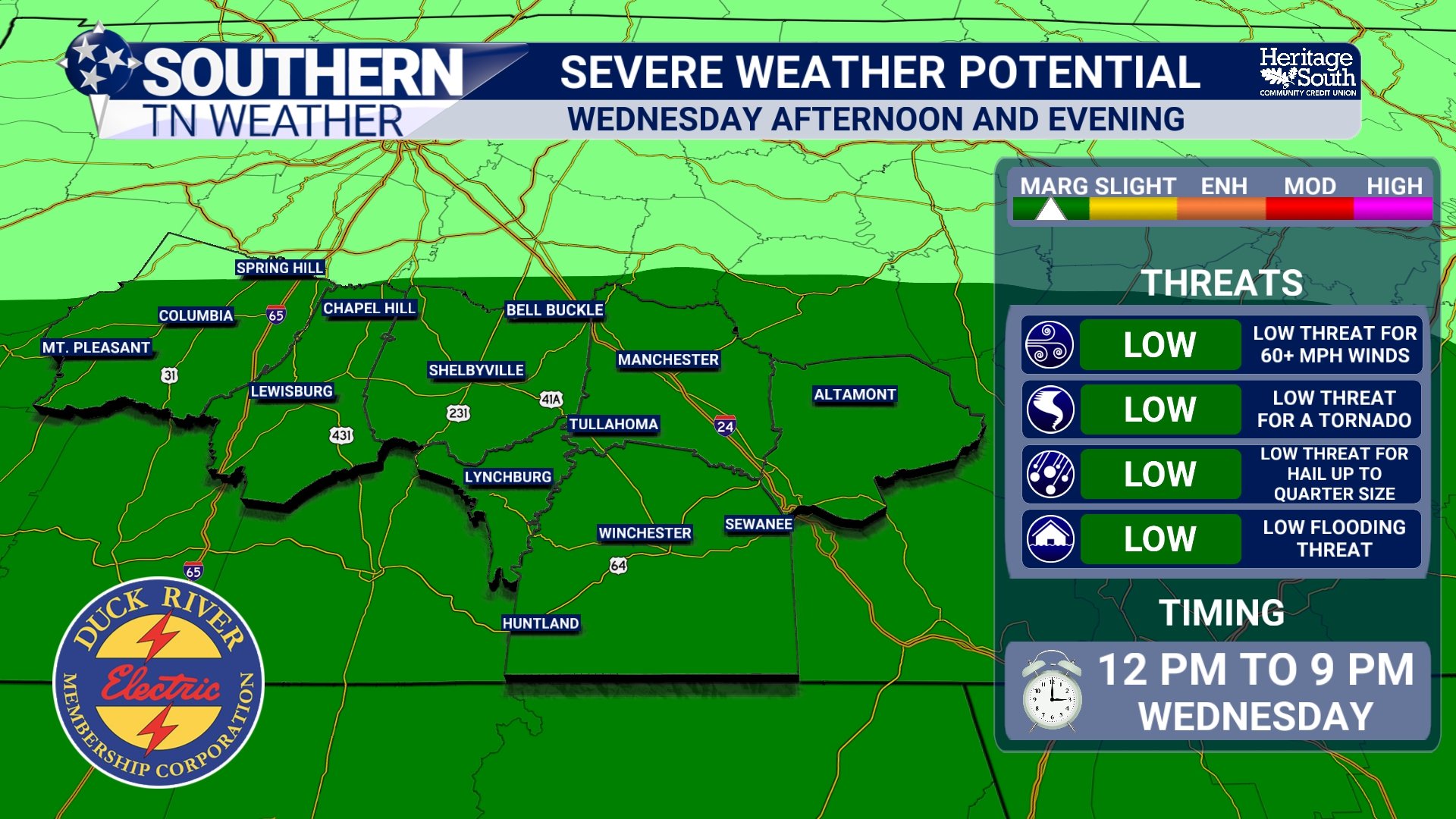
SEVERE WEATHER POTENTIAL - WEDNESDAY
INTO THURSDAY: GRADUAL IMPROVEMENT
As the main trough pushes east, the stalled front will finally get moving again. Rain will taper off from west to east into Wednesday night, with some lingering showers possible into Thursday. Behind the system, cooler air will filter back into the region, and temperatures will settle back below normal to close out the week.
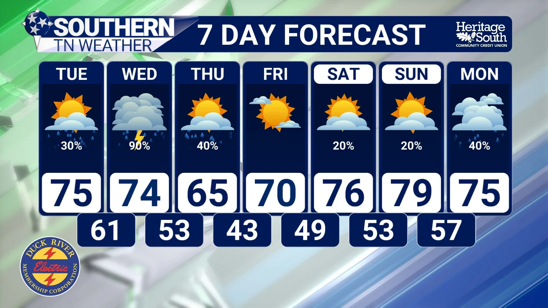
7-DAY FORECAST
The Bottom Line 🧾
Rain develops Tuesday, becoming more widespread into Tuesday night
Heaviest rain expected Tuesday night through Wednesday evening
Rainfall totals of 1.5 to 3 inches possible
Localized flooding possible, especially in low-lying or poor drainage areas
Severe weather threat is low, but not completely zero
A few stronger storms possible mainly south of I-40
Cooler, drier air returns late Wednesday into Thursday
📰 Reminder: The Southern Tennessee Weather Blog, presented by Heritage South Community Credit Union, is updated Monday through Friday with fresh, locally tailored forecasts you can trust.