

The Southern Tennessee Weather Blog is proudly presented by Heritage South Community Credit Union.
We Help When Others Won’t!
Visit https://www.heritagesouth.org/ today to see how HSCCU can help YOU!
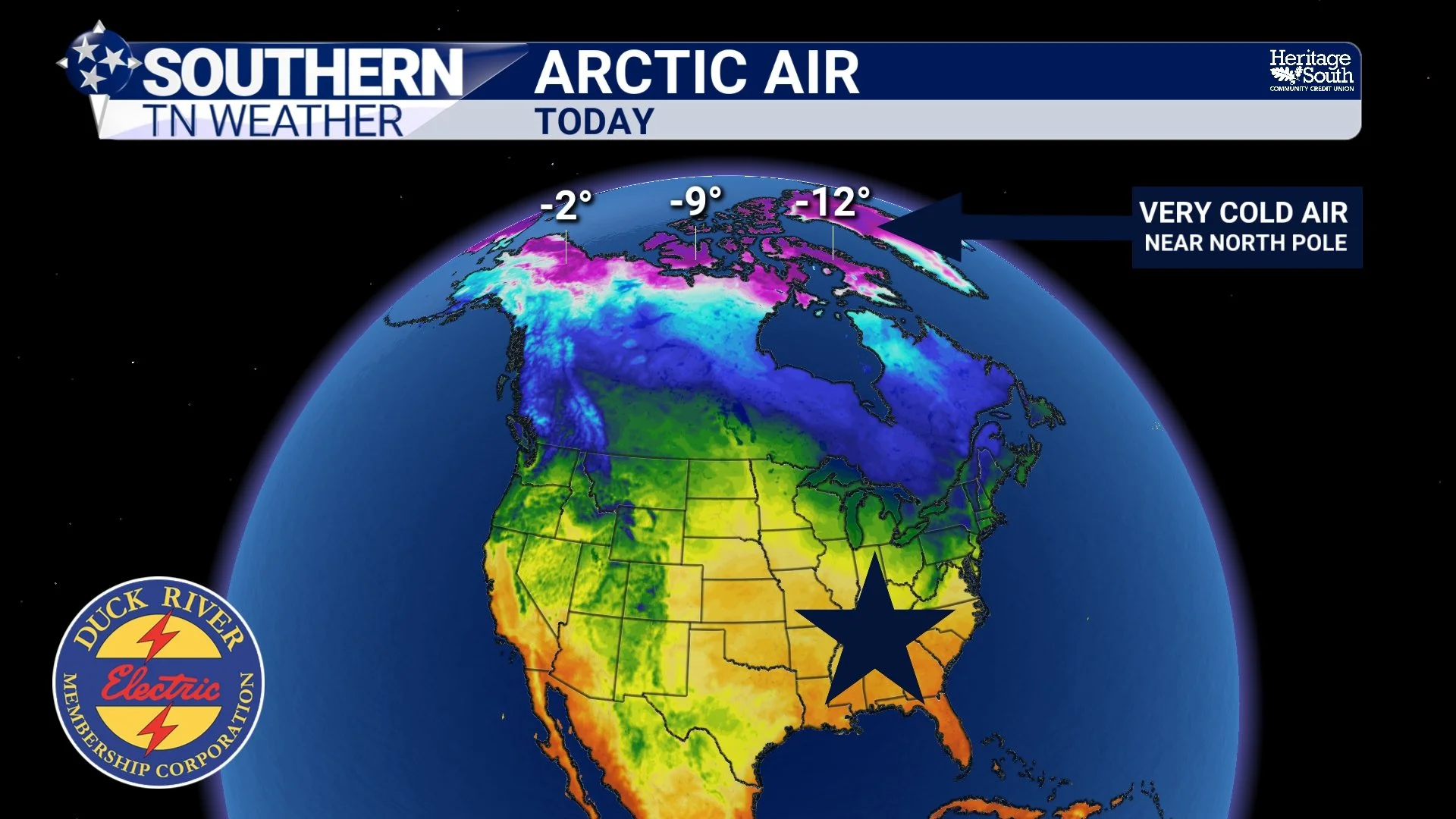
Have you ever wondered how air that originated thousands of miles away, somewhere in the frozen Arctic, can eventually make its way all the way down to Southern Middle Tennessee? I mean, think about that for a second. We're talking about air that develops over some of the coldest places on Earth, where winter temperatures can fall WELL below zero, somehow traveling across Canada and much of the United States before eventually reaching our own backyards!
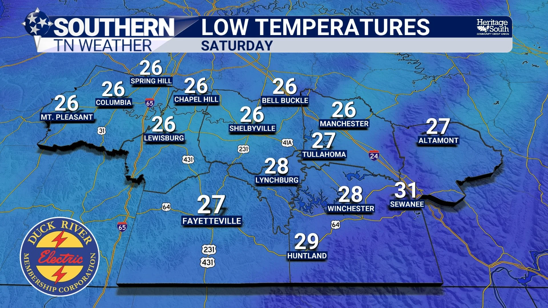
And believe it or not, we're about to experience a pretty good example of how this process works. After enjoying afternoon temperatures approaching 70 degrees through the first half of this week, a powerful cold front is expected to move through Southern Middle Tennessee Thursday, opening the door for some of the coldest air we've experienced so far this season. By Friday night into Saturday morning, temperatures could fall into the middle 20s across much of our region, potentially bringing our first widespread HARD FREEZE of the 2026–27 winter season.
But where does that cold air actually come from? How does it manage to travel so far south? And what role does the jet stream play in allowing Arctic air to escape its usual home near the North Pole? The answers involve some pretty fascinating atmospheric processes, and understanding them can help explain why our weather sometimes changes so dramatically in just a matter of days.
Where Does Arctic Air Actually Come From?
First, we need to understand how extremely cold air develops in the first place. Meteorologists classify large bodies of air based on their temperature and moisture characteristics, and we call these air masses. An air mass can cover hundreds or even thousands of miles, and its characteristics are largely determined by the region where it develops.
For example, air that forms over warm tropical waters is generally warm and humid, while air that develops over the frozen landscapes of northern Canada and the Arctic is typically very cold and dry. Meteorologists refer to these especially cold air masses as continental Arctic air, or cA for short. We also have continental polar air, or cP, which develops over higher northern latitudes but generally isn't quite as cold as true Arctic air.
During the winter months, the Arctic receives very little sunlight. In fact, areas near the North Pole can go weeks or even months without seeing the sun rise above the horizon! Without incoming solar energy to warm the surface, temperatures can fall dramatically. Snow and ice also reflect much of the limited sunlight that does arrive, while long winter nights allow the ground to continuously lose heat.
Over time, the air immediately above these frozen surfaces becomes extremely cold. Because colder air is denser than warmer air, large areas of high atmospheric pressure frequently develop within these frigid air masses. These are sometimes called Arctic high-pressure systems, and they can contain some remarkably cold air. Now, here's something interesting. The air doesn't necessarily remain in the same place where it formed. Our atmosphere is constantly moving, and when the larger weather pattern becomes favorable, these massive pools of cold air can begin traveling southward.
And that's where the jet stream comes into play!
The Jet Stream: A Highway for Cold Air?
You've probably heard me mention the jet stream countless times during our weather discussions. It's one of the most important features in our atmosphere, and it plays a MAJOR role in determining whether Southern Middle Tennessee experiences unusually warm weather, bitterly cold temperatures, or something in between.
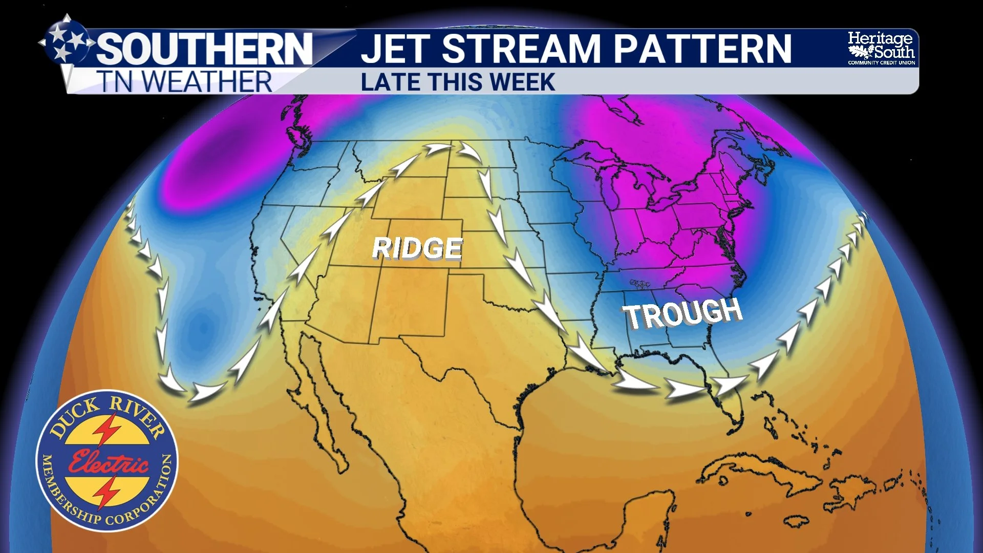
The jet stream is a relatively narrow corridor of very strong winds located several miles above Earth's surface, generally around 30,000 feet. These winds typically blow from west to east, sometimes reaching speeds well over 100 MPH. However, the jet stream doesn't travel in a perfectly straight line around the planet. Instead, it bends, curves, and occasionally develops enormous northward and southward dips.
Meteorologists refer to these large bends as ridges and troughs. A ridge is a northward bulge in the upper-level flow, often associated with warmer conditions beneath it. A trough, on the other hand, is a southward dip that frequently allows colder air to spread into lower latitudes.
Think of the jet stream as a winding river moving across North America. Sometimes that river flows relatively straight from west to east, keeping the coldest air confined to Canada and the northern United States. Other times, the river develops a large southward bend, creating a pathway for colder air to move much farther south than usual. When a particularly deep trough develops across the eastern United States, northerly winds on the backside of that trough can help transport cold air southward from Canada. At the same time, the overall pressure pattern near the ground can support a strong push of cold air into the central and eastern United States.
And if that trough becomes deep enough, Arctic or polar air can make it all the way into Tennessee, Alabama, Georgia, and occasionally even Florida! Now, the jet stream isn't literally picking up cold air and carrying it southward like a conveyor belt. Instead, the larger atmospheric circulation associated with these ridges and troughs helps establish the wind patterns that transport air masses across the continent.
It's a complicated process, but the basic idea is pretty simple: When the atmosphere develops a favorable pathway, cold air that normally stays far to our north can begin moving toward Southern Middle Tennessee.
How Can Cold Air Travel That Far Without Warming Up?
This is probably one of the most interesting questions of all. If Arctic air begins moving southward across Canada and the United States, shouldn't it gradually warm up as it travels over areas that are warmer than where it originated? Well, YES! And in many cases, that's exactly what happens.
As a cold air mass travels southward, it interacts with the ground beneath it. If the ground is warmer than the air, heat can transfer upward from the surface, gradually modifying the air mass. Sunshine, cloud cover, wind, and the characteristics of the terrain all influence how quickly that warming occurs.
However, there are several reasons why extremely cold air can maintain much of its character over such long distances. First, these air masses are often ENORMOUS. We're not talking about a small pocket of cold air moving across a few counties. An Arctic outbreak can involve a massive area of cold air extending across much of Canada and the United States. It takes a considerable amount of energy to warm such a large volume of air.
Second, the air frequently travels over surfaces that are already quite cold. During the winter, snow-covered landscapes across Canada and the northern United States can help limit how much warming occurs as the air moves southward. In some situations, the air can even continue cooling as it passes over extremely cold surfaces.
Third, strong northerly winds can continually transport additional cold air into the region. Meteorologists call this cold air advection, which simply means colder air is being carried into an area by the wind.
That's why temperatures can continue falling even during the daytime after a powerful cold front passes. Normally, sunshine helps warm the ground and surrounding air during the afternoon. However, if cold air advection is strong enough, the atmosphere may continue replacing relatively warmer air with colder air faster than daytime heating can compensate. And that's when we can experience those REALLY cold afternoons where temperatures struggle to climb out of the 30s or 40s despite some sunshine!
By the time an Arctic air mass reaches Southern Middle Tennessee, it has usually undergone some modification. That's why we don't routinely experience the extreme temperatures found across northern Canada. Nevertheless, the air can still be substantially colder than what we normally expect at our latitude.
What About the Polar Vortex? Is That Responsible?
Now, I know what some of you are probably thinking. What about the POLAR VORTEX? Every winter, it seems like we hear that term whenever a significant cold outbreak threatens the United States. And while the polar vortex can certainly influence our weather, there's quite a bit of misunderstanding surrounding what it actually is.
First, the polar vortex isn't some mysterious new weather phenomenon that suddenly appears whenever temperatures drop below freezing. It's a large-scale circulation of cold air and low pressure surrounding the polar regions, and it exists throughout the year, although its strength and structure change with the seasons.
Meteorologists also distinguish between the polar vortex in the troposphere, where most of our everyday weather occurs, and the stratospheric polar vortex located much higher in the atmosphere. When the polar circulation becomes particularly strong and relatively compact, the coldest air often remains concentrated closer to the Arctic. However, when the circulation becomes more distorted or develops large southward extensions, colder air can spread into the middle latitudes. Sometimes, disturbances involving the stratospheric polar vortex can influence weather patterns lower in the atmosphere, potentially increasing the likelihood of significant cold outbreaks weeks later. However, that connection isn't automatic, and the atmosphere doesn't always respond in the same way.
Here's the important part: NOT EVERY COLD OUTBREAK IS CAUSED BY A POLAR VORTEX DISRUPTION! We can experience substantial cold air outbreaks across Tennessee simply because the jet stream develops a deep trough and the surface pressure pattern becomes favorable for transporting colder air southward. In fact, many of our typical winter cold fronts occur without any unusual disruption of the stratospheric polar vortex. So, the next time you hear someone say the polar vortex is coming to Tennessee, remember that the situation is usually more complicated than that. What we're actually experiencing at the surface is the arrival of a cold air mass, influenced by the larger atmospheric circulation.
Why Does Tennessee Sometimes Get Colder Than Places Farther North?
Here's another fascinating aspect of Arctic outbreaks. Believe it or not, there are situations where Southern Middle Tennessee can briefly experience temperatures colder than locations hundreds of miles farther north! How is that possible? It all comes down to the positioning of the upper-level trough, the movement of the cold air mass, and local conditions near the ground.
If a particularly deep trough develops across the eastern United States, the coldest air may become concentrated over portions of the Midwest, Ohio Valley, and Southeast. Meanwhile, areas farther north or west could experience a ridge of high pressure aloft, allowing temperatures to become relatively warmer. That doesn't mean Tennessee is suddenly colder than the Arctic itself. It simply means the coldest part of the air mass may have shifted southward while other regions experience different weather patterns.
Local geography also plays an important role in determining how cold individual communities become. Across Southern Middle Tennessee, our valleys and sheltered hollows can experience substantially colder overnight temperatures than nearby hilltops, particularly when skies are clear and winds become light. This happens because cold, dense air tends to drain downhill and collect in lower elevations. Meteorologists call this cold-air drainage, and it can create surprisingly large temperature differences over relatively short distances.
For example, a hilltop near Shelbyville might remain around 30 degrees while a sheltered valley near Normandy drops into the middle 20s under favorable conditions. That's why our local geography becomes especially important when forecasting frost and freezing temperatures!
Now, Let's Talk About This Week's BIG Cooldown!
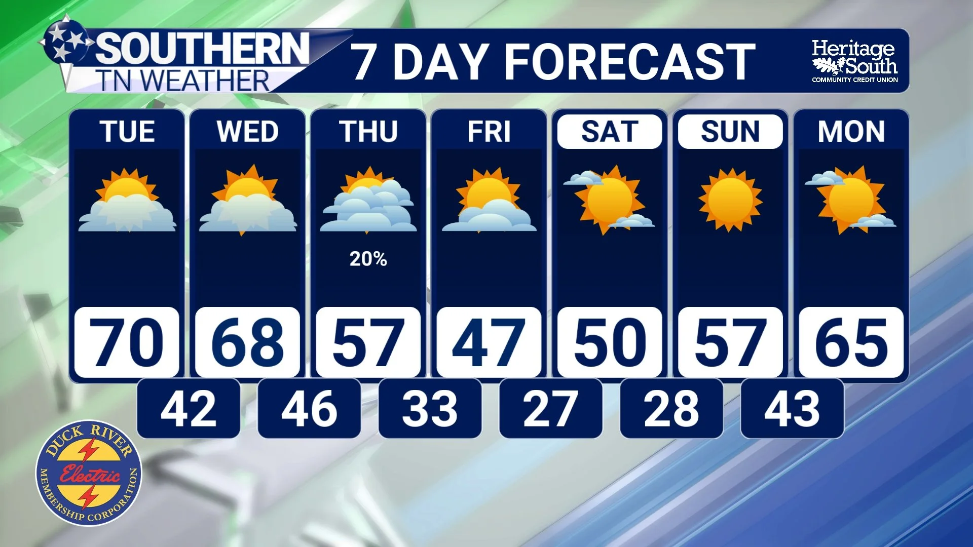
All of this brings us to the weather pattern developing across Southern Middle Tennessee later this week. We're starting the week on a relatively mild note, with afternoon temperatures approaching 70 degrees Monday, Tuesday, and Wednesday. High pressure will help maintain dry conditions through much of Wednesday, although some morning fog and patchy frost will remain possible in our colder valleys.
However, a significant change is expected to develop across the central and eastern United States during the middle of the week. A large upper-level low-pressure system is forecast to organize near the Great Lakes, with a deep trough extending southward into portions of the eastern United States. As that trough strengthens, a cold front will approach Southern Middle Tennessee from the northwest, bringing increasing rain chances Wednesday evening into early Thursday.
At this point, widespread rainfall totals of approximately 0.10–0.25 inches appear possible across much of our region. That's certainly not a soaking rainfall, but considering our ongoing drought conditions, we'll take whatever beneficial moisture we can get! A few thunderstorms may also develop, although the overall severe weather potential currently appears very low. Once the cold front moves through Thursday, the REALLY noticeable changes begin.
Strong northerly to northwesterly winds will transport a much colder air mass into Southern Middle Tennessee, with temperatures dropping substantially by Friday. Afternoon highs Friday may struggle to climb beyond the middle to upper 40s in some communities, particularly across the Cumberland Plateau. And yes, there's even a small possibility of a few scattered SNOW FLURRIES on Friday!
The best opportunity for flurries would likely be across the higher elevations of the Cumberland Plateau, including portions of Grundy / Franklin County near Monteagle, Sewanee, and Altamont. As colder air moves across the region, lingering low-level moisture and favorable atmospheric conditions could support a few passing flurries. However, I want to emphasize that I'm NOT expecting any meaningful snowfall accumulations or travel impacts. Chances for flurries decrease considerably as you move westward off the Plateau, and many communities may not see a single flake.
The much bigger story will be the cold temperatures arriving Friday night into Saturday morning. Current forecast guidance suggests that overnight lows could fall into the middle 20s across much of Southern Middle Tennessee, with some colder valleys potentially dropping a little lower. That would likely bring our first widespread HARD FREEZE of the 2026–27 winter season!
For reference, a hard freeze generally occurs when temperatures fall to 28 degrees or lower for a sufficient period to damage or kill many types of vegetation. While we've already experienced some light frost and isolated freezing temperatures this fall, this upcoming cold outbreak looks considerably more substantial. And the cold weather may stick around for more than just one night.
Another round of temperatures in the 20s appears possible Saturday night into Sunday morning, with afternoon highs Sunday potentially struggling to climb beyond the upper 40s to lower 50s. That's quite a change from the nearly 70-degree temperatures we're expecting during the first half of the week!
Now, one thing worth mentioning is that this particular cold outbreak is arriving during early November, when the ground hasn't had nearly as much time to cool as it would during January or February. That means the air mass will undergo some modification as it moves southward. Nevertheless, the larger atmospheric pattern looks favorable for delivering a substantial shot of cold air into our region. And after several weeks of unusually warm weather, I think we're all going to notice the difference!
The Bottom Line 🧾
Where does Arctic air come from? Extremely cold air masses develop over the Arctic and northern Canada, where limited winter sunlight and snow-covered surfaces allow temperatures to fall dramatically.
How does it reach Tennessee? Large-scale atmospheric circulation, including deep upper-level troughs and northerly winds, can transport cold air thousands of miles southward.
What role does the jet stream play? Southward dips in the jet stream help establish favorable pathways for colder air to move into the central and eastern United States.
Is it always the polar vortex? NO! Significant cold outbreaks can occur without an unusual disruption of the stratospheric polar vortex.
Monday through Wednesday: Mild and mostly dry, with afternoon highs approaching 70 degrees.
Wednesday evening into Thursday: Rain chances return ahead of a strong cold front. Rainfall totals of approximately 0.10–0.25 inches appear possible.
Friday: MUCH colder! Afternoon highs may struggle to climb beyond the middle to upper 40s, especially across higher elevations.
Snow flurries? A few scattered flurries are possible Friday, particularly along the Cumberland Plateau. No accumulations or travel impacts are expected.
Friday night into Saturday morning: Widespread HARD FREEZE conditions are likely, with temperatures falling into the middle 20s across much of Southern Middle Tennessee.
Saturday night into Sunday morning: Another round of freezing temperatures is possible, with lows again dropping into the 20s in many communities.
Protect sensitive vegetation: This upcoming cold outbreak could effectively bring the growing season to an end across much of our region.
📰 Reminder: The Southern Tennessee Weather Blog, presented by Heritage South Community Credit Union, is updated Monday through Friday with fresh, locally tailored forecasts you can trust
