

The Southern Tennessee Weather Blog is proudly presented by Heritage South Community Credit Union.
We Help When Others Won’t!
Visit https://www.heritagesouth.org/ today to see how HSCCU can help YOU!
Well, after a rather active start to November, it looks like Mother Nature is getting ready to give us a BEAUTIFUL weekend across Southern Middle Tennessee! We've finally picked up some much-needed rainfall over the past several days, and now we're transitioning back into a quieter weather pattern featuring plenty of sunshine, dry conditions, and some rather chilly temperatures. In fact, some of our communities could experience their first freezing temperatures of the season before the weekend is over!
But before you get too excited about the sunshine, you might want to dig those jackets out of the closet! A reinforcing cold front is moving through Southern Middle Tennessee today, bringing a noticeably cooler air mass into our region. And while this front won't produce much in the way of rainfall, it WILL deliver some of the chilliest temperatures we've experienced so far this fall.
The biggest story heading into the weekend isn't necessarily what happens during the afternoon. It's what happens overnight, particularly Saturday night into Sunday morning, when temperatures could fall to near or below freezing across portions of our area. And believe it or not, we may have ANOTHER opportunity for frost or freezing temperatures Sunday night into Monday morning! So, let's take a closer look at what we can expect over the next several days and why our temperatures are about to take a pretty substantial tumble.
A Dry Cold Front? Yes, That's Actually a Thing!
If you've been following our recent weather discussions, you know we've experienced several rounds of rainfall associated with approaching cold fronts. However, today's cold front is a little different. Instead of bringing another widespread soaking, it's primarily responsible for transporting a colder and drier air mass into Southern Middle Tennessee. Now, I know what some of you are thinking. How can a cold front move through without producing rain?
Well, the answer comes down to atmospheric moisture. While cold fronts provide a mechanism for lifting air upward, they still need sufficient moisture in the atmosphere to produce clouds and precipitation. In this particular situation, the atmosphere is relatively dry, which means there simply isn't enough moisture available to support widespread rainfall.
That's why today's frontal passage will be relatively uneventful from a precipitation standpoint. We may notice some additional cloud cover and perhaps a stray sprinkle or patch of drizzle in a few locations, but the overwhelming majority of Southern Middle Tennessee should remain dry. What we WILL notice is a change in the wind. As the front moves through, winds will turn toward the north and northwest, occasionally gusting around 15–20 MPH. Those winds will help transport cooler air southward from Canada, gradually replacing the warmer air we've experienced throughout much of the week.
Afternoon temperatures Friday should generally climb into the lower to middle 60s, with some of our southern communities potentially reaching the upper 60s. However, the combination of increasing clouds and a northwest breeze will make it feel noticeably cooler than the unusually warm conditions we experienced earlier this week. And once the sun goes down, temperatures will begin falling rather quickly!
Friday night will feature clearing skies and diminishing winds, with overnight lows generally dropping into the middle to upper 30s across much of Southern Middle Tennessee. Some of our colder valleys could approach the freezing mark, although the more widespread frost and freeze potential is expected later in the weekend.
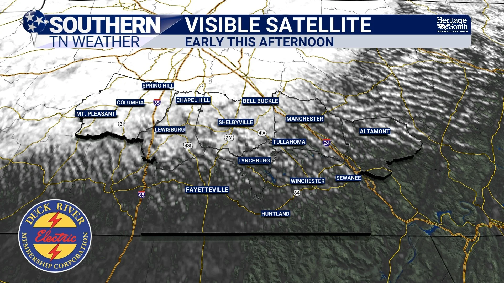
Saturday: Plenty of Sunshine, but a Noticeable Chill!
Saturday is shaping up to be a beautiful November day, at least if you don't mind the cooler temperatures! High pressure will gradually settle across our region, bringing mostly sunny skies and dry conditions throughout the day. However, the colder air mass behind Friday's front will be firmly established, meaning afternoon temperatures will struggle to climb very high.
I'm generally expecting highs in the upper 50s to lower 60s across Southern Middle Tennessee, with some of our colder communities and higher elevations remaining in the middle 50s. The Cumberland Plateau will likely be among the coolest locations, particularly around Monteagle, Sewanee, and Altamont. That's quite a change from the middle to upper 70s we experienced just a few days ago!
North winds will continue around 5–10 MPH during the afternoon, adding a little extra chill to the air. However, with plenty of sunshine expected, Saturday should still be a pretty enjoyable day for outdoor activities. Whether you're working around the yard, heading to a local event, or simply enjoying some time outside, I'd recommend keeping a jacket handy. But the REALLY interesting part of Saturday's forecast arrives after sunset.
As high pressure settles directly over Southern Middle Tennessee, winds will become lighter and skies should remain mostly clear. That combination creates an ideal environment for something meteorologists call radiational cooling. During the daytime, the ground absorbs energy from the sun. Once the sun sets, that energy begins escaping back into the atmosphere and eventually into space. When skies are clear and winds are light, the ground can lose heat rather efficiently, allowing temperatures near the surface to fall quickly.
And that's exactly the setup we're expecting Saturday night!
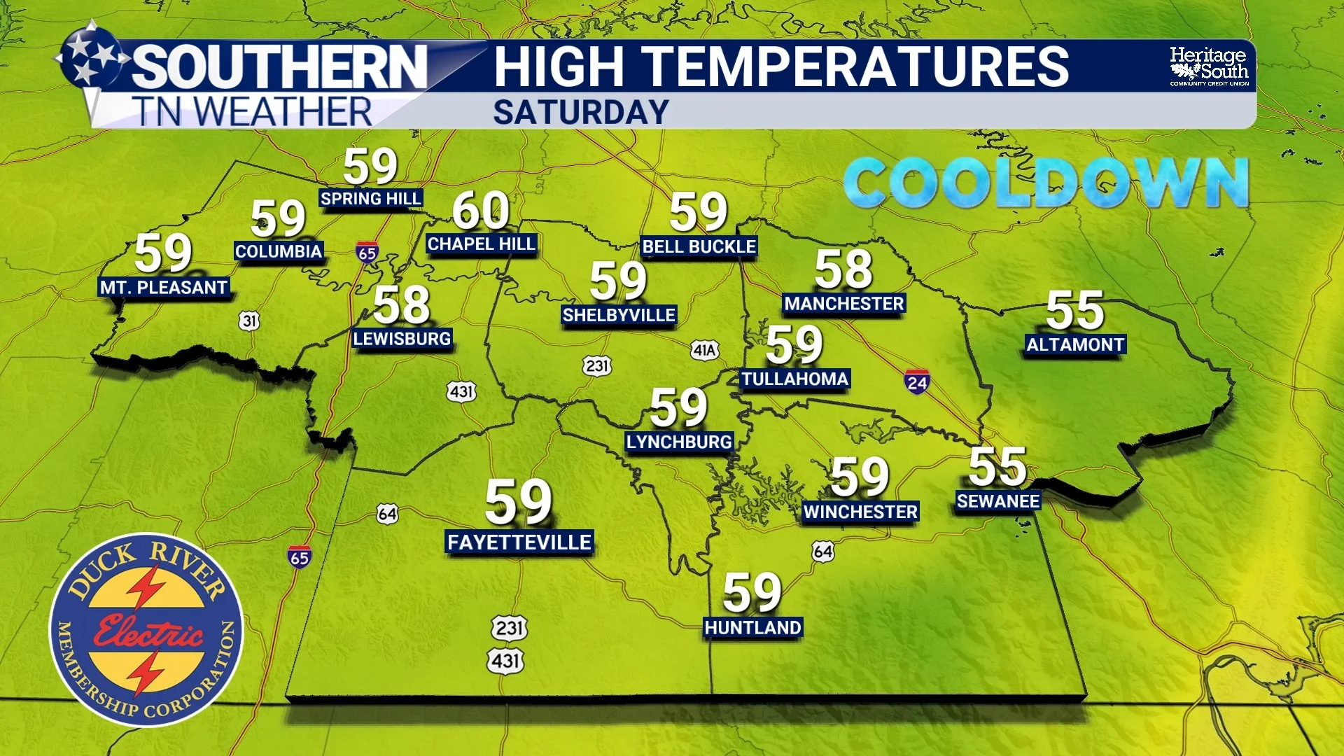
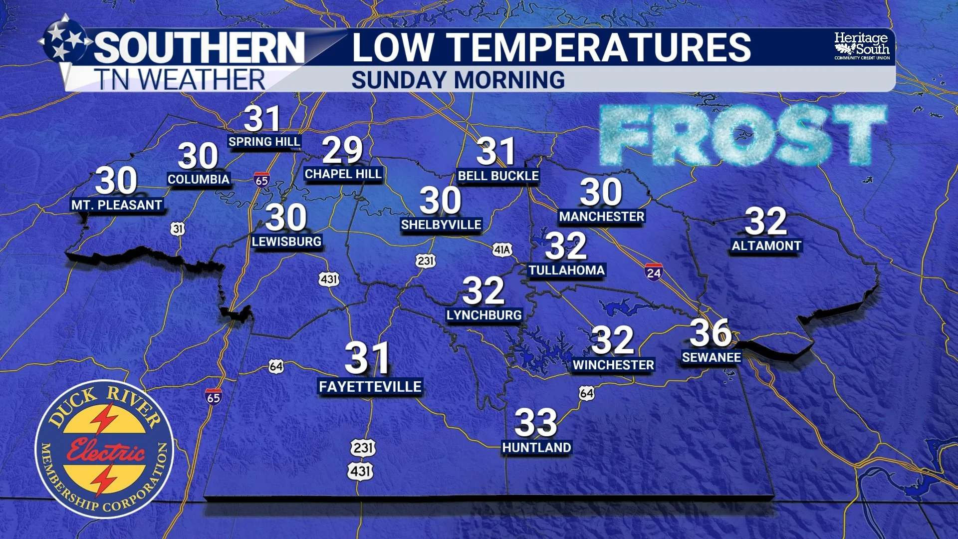
Saturday Night Into Sunday Morning: Our First Freeze?
This is the part of the forecast I want everyone to pay particularly close attention to, especially if you've still got sensitive plants outside. Current guidance suggests that temperatures will fall into the lower to middle 30s across much of Southern Middle Tennessee Saturday night into Sunday morning. However, some of our colder valleys, sheltered hollows, and higher elevations could drop into the upper 20s.
That means FROST and FREEZING temperatures are becoming increasingly likely across portions of our region! Now, there's an important distinction between frost and a freeze. Frost forms when moisture deposits as ice crystals on exposed surfaces that have cooled to freezing or below. This can happen even when the official air temperature, measured several feet above the ground, remains slightly above 32 degrees.
A freeze, on the other hand, occurs when the air temperature itself falls to 32 degrees or lower. Depending on how long temperatures remain below freezing, sensitive vegetation can experience damage or even be killed. In this particular setup, the greatest potential for freezing temperatures will likely be across our colder valleys and sheltered communities.
The Cumberland Plateau will also have an opportunity to experience freezing temperatures, although the exact temperatures there will depend on elevation, wind exposure, and how efficiently the atmosphere cools overnight. One thing worth remembering is that colder air is denser than warmer air, which means it tends to settle into valleys and other low-lying areas when winds become light. Meteorologists refer to this as cold-air drainage, and it's one of the reasons temperatures can vary so dramatically over relatively short distances during clear, calm nights.
You might have a temperature of 36 degrees on a nearby hilltop while a sheltered valley just a few miles away drops to 29 degrees! That's why I always emphasize the importance of local geography when discussing frost and freeze potential across Southern Middle Tennessee. If you've got sensitive plants outside, I'd recommend bringing them indoors or covering them before Saturday evening. It's also a good idea to make sure outdoor pets have adequate shelter from the cold.
And if we don't quite reach freezing in your community Sunday morning, don't assume we're completely out of the woods just yet!
Sunday: A Beautiful Afternoon, but Another Cold Night Ahead!
After a rather chilly start Sunday morning, temperatures will gradually recover as sunshine returns to Southern Middle Tennessee. I'm expecting mostly sunny skies throughout the day, with afternoon highs generally climbing into the lower to middle 60s. That's a few degrees warmer than Saturday, but still noticeably cooler than the temperatures we experienced earlier this week.
Winds should remain relatively light as high pressure continues dominating our weather. That means Sunday should be an excellent day for outdoor activities, particularly during the afternoon when temperatures become a little more comfortable. However, the same atmospheric conditions responsible for Saturday night's chilly temperatures could develop again Sunday night.
With clear skies, light winds, and a relatively dry air mass in place, temperatures may once again fall into the lower to middle 30s across much of Southern Middle Tennessee. Some of our colder communities could dip below freezing, especially in sheltered valleys and other locations that experience efficient overnight cooling. In fact, there's a reasonable possibility that Monday morning could be just as cold, or perhaps even a little colder, than Sunday morning in some locations.
That's something we'll continue watching closely over the next couple of days. The good news is that our afternoon temperatures will begin moderating as we head into the new workweek. Monday should feature plenty of sunshine, with highs climbing into the middle to upper 60s across much of our region. And that warming trend should continue through at least the middle of next week.
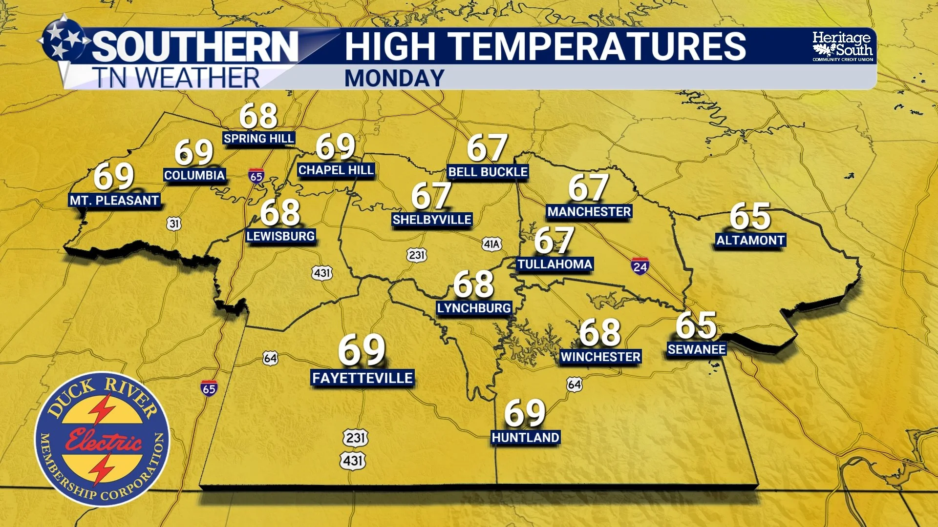
Looking Ahead: Sunshine Continues, but Where's the Next Rain?
Now, I know what some of you are probably thinking. After finally receiving some much-needed rainfall earlier this week, are we about to head right back into another extended dry stretch? Unfortunately, that's looking increasingly possible. The latest forecast guidance suggests that high pressure will remain a dominant feature across Southern Middle Tennessee through much of next week, keeping widespread rainfall opportunities VERY limited.
Monday through Wednesday should feature mostly sunny to partly cloudy skies, with afternoon temperatures gradually warming into the middle to upper 60s. Some communities could approach 70 degrees by the middle of the week. Overnight temperatures will also begin moderating, with lows gradually climbing back into the upper 30s and lower 40s.
Our next opportunity for precipitation may not arrive until late next week, when another weak disturbance could approach the region. However, confidence in meaningful rainfall with that system remains rather low, and some guidance suggests that most communities could remain dry. Considering our ongoing drought conditions, that's something worth monitoring.
As we discussed in Thursday's drought update, the rainfall we received over the weekend and Wednesday has certainly been beneficial, but it hasn't completely eliminated our moisture deficits. Severe to Extreme Drought continues across portions of Southern Middle Tennessee, and additional rainfall will be needed over the coming weeks to support more substantial recovery. The latest Climate Prediction Center outlooks also favor a relatively warm and dry pattern across Tennessee during the middle of November. That doesn't mean we won't see any rainfall, but it does suggest that widespread, significant precipitation opportunities may remain limited for a while.
For now, though, let's enjoy the sunshine and cooler temperatures heading our way this weekend. After all, it IS November, and I think it's about time Mother Nature reminded us what autumn is supposed to feel like!
The Bottom Line 🧾
Friday: Increasing clouds and a breezy northwest wind as a dry cold front moves through. Highs generally in the lower to middle 60s, with occasional gusts of 15–20 MPH.
Friday night: Clearing skies and chilly temperatures. Lows generally in the middle to upper 30s, with some colder valleys approaching freezing.
Saturday: Mostly sunny and COOL! Afternoon highs in the upper 50s to lower 60s, with some higher elevations remaining in the middle 50s.
Saturday night: FROST and FREEZING temperatures possible! Lows generally in the lower to middle 30s, with colder valleys potentially dipping into the upper 20s.
Sunday: A chilly start followed by a beautiful afternoon. Mostly sunny skies with highs in the lower to middle 60s.
Sunday night: Another opportunity for frost and freezing temperatures, particularly across sheltered valleys and colder communities.
Monday: Mostly sunny with temperatures gradually moderating. Highs in the middle to upper 60s.
Tuesday and Wednesday: Dry weather continues, with afternoon highs generally in the middle to upper 60s and overnight lows in the upper 30s to lower 40s.
Rain chances: VERY LOW through much of next week. Our next opportunity for precipitation may not arrive until late next week.
Drought concerns: Recent rainfall has helped, but additional precipitation will be needed for meaningful drought recovery.
📰 Reminder: The Southern Tennessee Weather Blog, presented by Heritage South Community Credit Union, is updated Monday through Friday with fresh, locally tailored forecasts you can trust
