
Halloween Forecast Update: Will Mother Nature Deliver TRICKS or TREATS This Weekend?

The Southern Tennessee Weather Blog is proudly presented by Heritage South Community Credit Union.
We Help When Others Won’t!
Visit https://www.heritagesouth.org/ today to see how HSCCU can help YOU!
WELL, WOULD YOU LOOK AT THAT! After spending more than two weeks begging Mother Nature for some much-needed rainfall across Southern Middle Tennessee, it looks like she may have finally heard our requests. There's just ONE little problem... She apparently decided HALLOWEEN WEEKEND would be the perfect time to deliver it! You seriously can't make this stuff up! With Halloween now just three days away, I know many of you are beginning to wonder what this approaching weather system will mean for trick-or-treating, fall festivals, and other outdoor activities Saturday evening. And believe it or not, we're finally beginning to get a better idea of how everything might unfold.
The good news? HALLOWEEN IS NOT LOOKING LIKE A GUARANTEED WASHOUT! In fact, there's a reasonable possibility that much of Saturday, including the early evening hours, could remain dry across Southern Middle Tennessee. However, rain chances will gradually increase as we head into Saturday night, with a much better opportunity for widespread rainfall developing overnight into Sunday morning. Before we get into the details, let's briefly discuss the remainder of our workweek. We're looking at another beautiful stretch of autumn weather, with a mixture of sunshine and clouds today and afternoon highs generally in the middle to upper 70s. Thursday and Friday will feature more pleasant conditions, with temperatures potentially approaching 80 degrees in some communities. Unfortunately, our ongoing drought will continue to worsen as dry conditions persist through Friday night. But as we head into the weekend, things FINALLY begin to change!
What's Changing in the Atmosphere?
If you've been keeping up with our recent weather blogs, you know we've spent quite a bit of time discussing the stubborn ridge of high pressure that's been dominating our weather pattern. This ridge has helped maintain sinking air, limited atmospheric moisture, and kept most organized storm systems away from Southern Middle Tennessee. However, that ridge is expected to weaken and flatten as we approach the weekend, allowing a disturbance in the upper atmosphere to move toward our region. At the same time, increasing southerly flow will help transport additional moisture northward, creating a much more favorable environment for clouds and precipitation.
The approaching system may also be accompanied by the development of a secondary area of low pressure. If that occurs, it could enhance atmospheric lift and influence the timing and coverage of rainfall across our region. And here's where things get interesting. While confidence is increasing that our overall weather pattern will become more active, there's still some uncertainty regarding exactly how quickly the system will arrive. That timing difference is particularly important because Halloween falls on Saturday this year. A system arriving six hours earlier could have a considerably different impact on trick-or-treating than one arriving six hours later.
Thankfully, the latest forecast guidance is beginning to provide some encouraging clues.
So, What Does Halloween Evening Actually Look Like?
Right now, I think there's a pretty good reason to remain cautiously optimistic about Saturday evening. Our latest forecast guidance suggests that rain chances will begin increasing sometime Saturday, but the better opportunity for widespread rainfall appears to hold off until late Saturday night and Sunday morning.
In fact, the latest National Blend of Models (NBM) guidance indicates that precipitation probabilities during the traditional trick-or-treating hours are currently BELOW 30% across much of Middle Tennessee. Now, that's certainly encouraging news! But I want to emphasize something important: A LOW CHANCE OF RAIN DOESN'T MEAN A ZERO CHANCE OF RAIN. It's entirely possible that a few scattered showers could develop during the afternoon or evening hours Saturday. However, based on the latest information, I'm not expecting widespread, persistent rainfall throughout the entire trick-or-treating period.
For those planning outdoor activities, I'd recommend keeping a rain jacket or umbrella nearby, just in case. But at this point, I certainly wouldn't be canceling Halloween plans over the forecast. Temperatures should also remain relatively comfortable for late October. We're generally expecting afternoon highs in the 70s Saturday, with temperatures gradually falling through the 60s during the evening hours. That means the weather should be fairly pleasant for trick-or-treating, assuming the rain holds off! Of course, this forecast is still subject to change. We're now close enough to Halloween that forecast confidence should continue improving over the next 24–48 hours, particularly regarding the timing of the approaching system.

Saturday Night Into Sunday: Our BEST Opportunity for Rainfall!
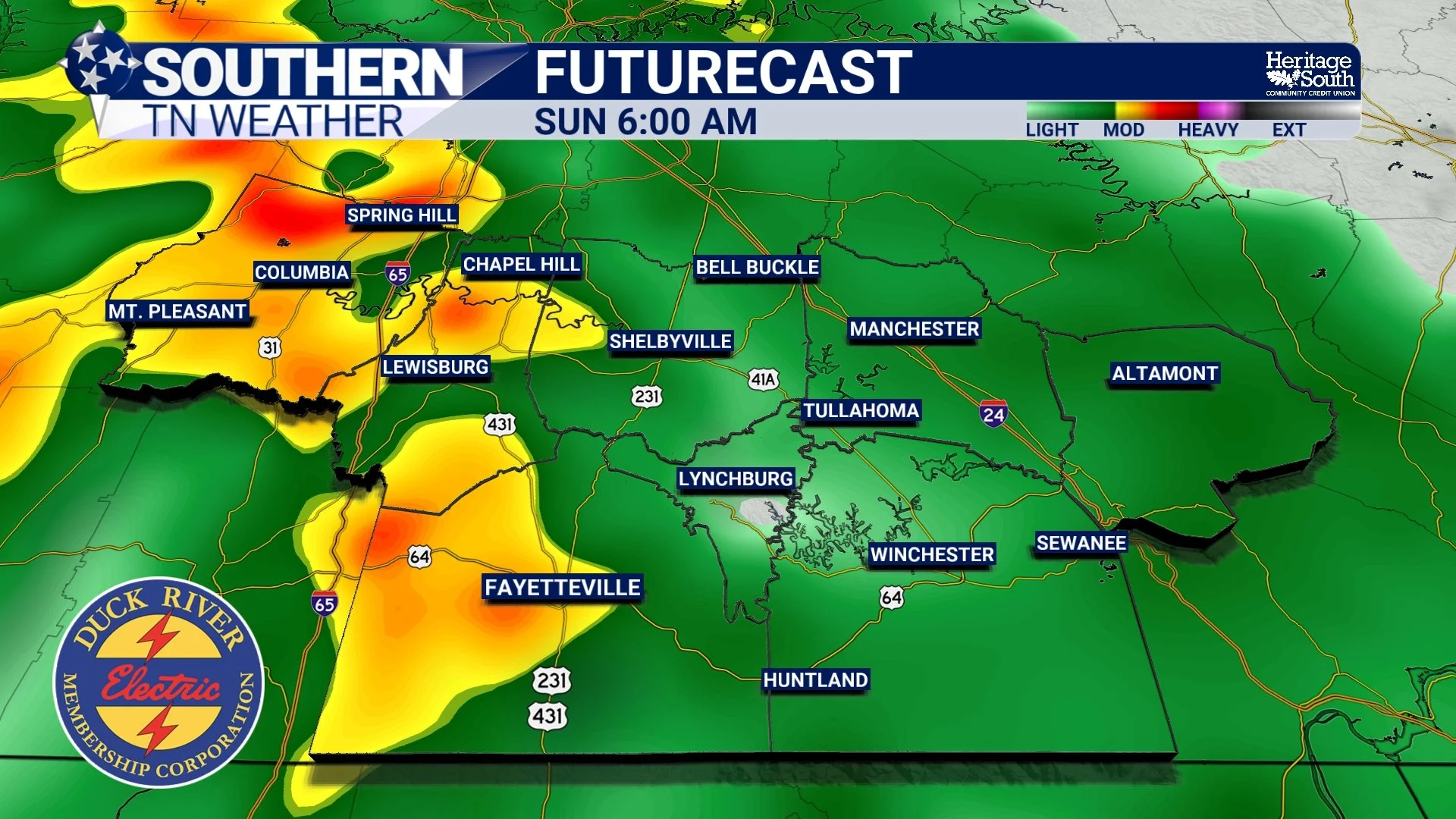
While Halloween evening may escape the worst of the rainfall, the forecast becomes considerably wetter as we head into the overnight hours. The most favorable period for widespread precipitation currently appears to be LATE SATURDAY NIGHT THROUGH SUNDAY MORNING, when the approaching disturbance and increasing atmospheric moisture should combine to produce a more organized area of rainfall. This could be our first meaningful, widespread rainfall event in more than two weeks, and considering how dry conditions have become across Southern Middle Tennessee, that's certainly something worth getting excited about!
Rainfall may continue at times into Sunday afternoon before gradually becoming less widespread as the system begins moving away from our region. There could even be a few embedded thunderstorms, particularly if enough instability develops. However, the overall atmospheric environment currently appears relatively stable, and organized severe weather is not expected with this weekend's system.
Temperatures will also respond to the increasing cloud cover and rainfall. After several days featuring afternoon highs in the upper 70s and near 80 degrees, Sunday should be noticeably cooler, with highs generally in the 60s. And after weeks of sunshine and dry weather, I think a cloudy, rainy Sunday might actually be a welcome change for quite a few people!
How Much Rainfall Could We Actually Receive?
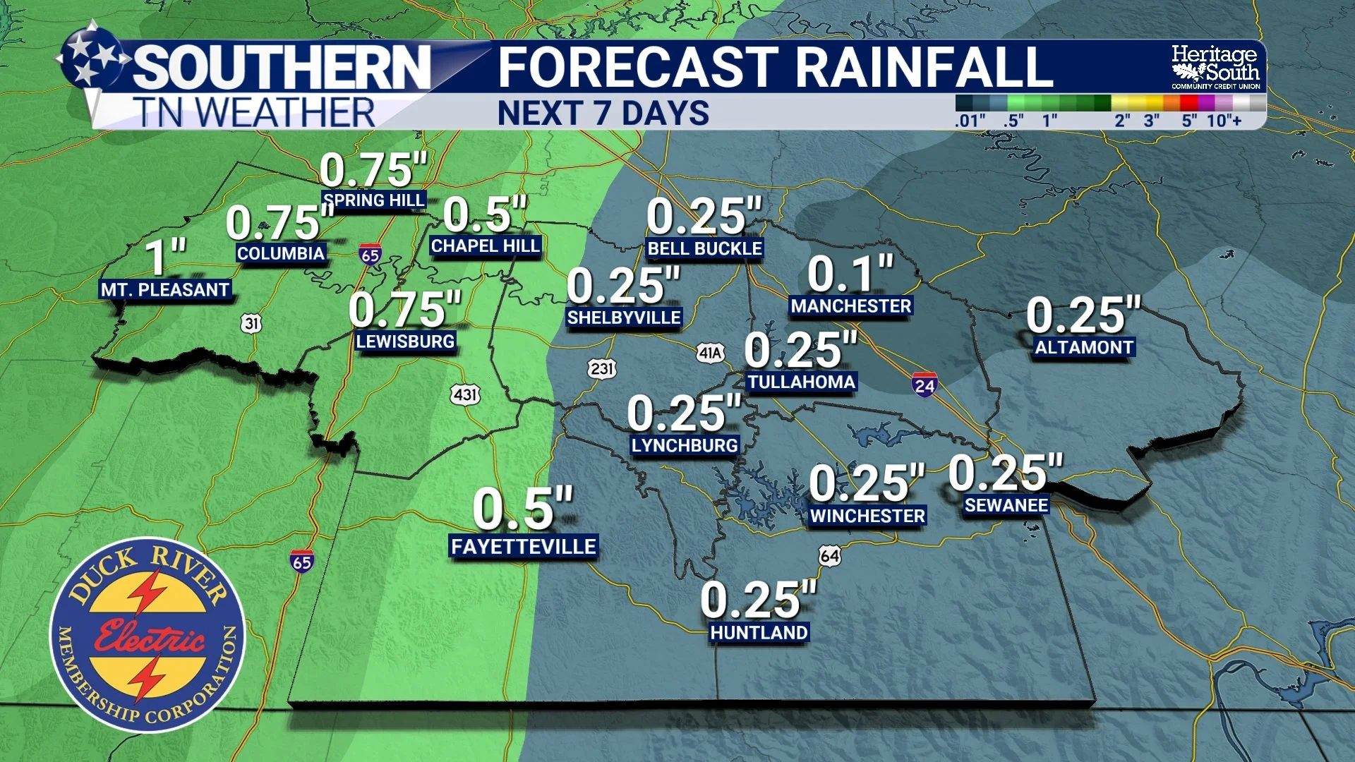
Now, here's the question I've probably received more than any other over the past several days: HOW MUCH RAIN ARE WE GOING TO GET? And while I wish I could give everyone a specific number, we're still dealing with some uncertainty regarding rainfall totals.
The latest forecast guidance suggests that portions of Middle Tennessee could receive anywhere from around one-half inch to more than an inch of rainfall through the middle of next week, with some locations potentially receiving higher totals if multiple systems develop favorably. And as we discussed in yesterday's weather blog, computer-model rainfall projections can change considerably as new information becomes available. A slight shift in the track of an approaching disturbance could influence where the heaviest rainfall develops. Likewise, differences in atmospheric moisture and the speed of the system could affect how much precipitation ultimately reaches the ground.
That's why I'm still hesitant to get too specific with rainfall totals several days in advance. Nevertheless, the overall trend toward a wetter weather pattern is certainly encouraging. After more than two weeks without meaningful rainfall, even a moderate soaking rain would be beneficial for our increasingly dry soils and vegetation. However, one rainfall event isn't going to magically eliminate our ongoing drought. We've accumulated substantial moisture deficits over the past several weeks, and meaningful drought recovery will likely require additional rainfall events over an extended period. Which brings us to another interesting development in the forecast!
Could ANOTHER Weather System Arrive Next Week?
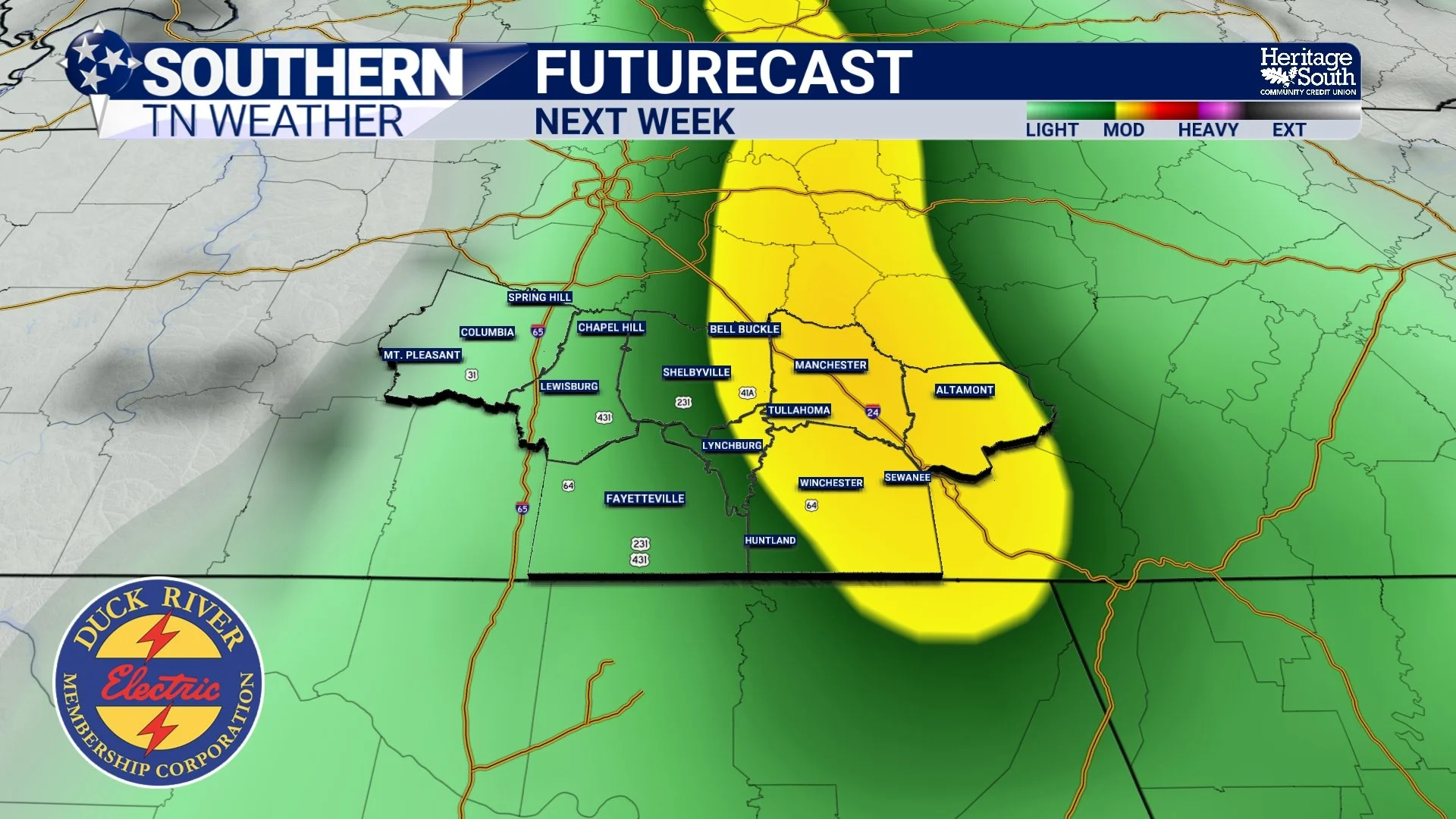
Believe it or not, our Halloween weekend system might only be the beginning of a more active weather pattern! After the first disturbance moves through Sunday, there are indications that another, potentially stronger weather system could approach the region during the first half of next week. This second system may be associated with a more substantial upper-level trough developing across the central United States, along with a surface low-pressure system and an accompanying cold front.
If the atmosphere can recover enough moisture between systems, this could provide another opportunity for widespread rainfall and perhaps a few thunderstorms. However, the exact timing remains uncertain. Some guidance suggests precipitation could return as early as Monday, while other solutions favor a later arrival, potentially Tuesday night into Wednesday.
That's a fairly significant difference, and it's something we'll need to monitor over the next several days. It's also worth noting that Tuesday is Election Day, so the timing of this second system could eventually become important for anyone planning to head to the polls. At this point, it's simply too early to confidently determine whether the second system will bring widespread rainfall, thunderstorms, or a combination of both. What we CAN say is that the atmosphere appears to be transitioning away from the stagnant, dry pattern we've experienced throughout much of October. And that's probably the most encouraging development of all!
Why I'm Still Watching the Halloween Forecast Closely
Even though the latest guidance is somewhat encouraging for trick-or-treating, I want to explain why we're not completely out of the woods just yet. The approaching weather system involves several interacting atmospheric features, including the weakening ridge, an approaching upper-level disturbance, increasing moisture, and the possibility of secondary low-pressure development. Small changes in any of those features could influence the arrival time of precipitation.
For example, if the approaching disturbance becomes better organized or moves eastward faster than currently anticipated, rainfall could begin earlier Saturday. On the other hand, if the system develops more slowly, the better precipitation chances might remain delayed until well after midnight. This is exactly why we don't want to become overly confident in a specific forecast several days before an event. The encouraging news is that forecast models are beginning to show better agreement on the general evolution of our weather pattern. We're becoming increasingly confident that meaningful rainfall opportunities will return this weekend, even though the precise timing remains somewhat uncertain.
Over the next couple of days, I'll be paying particularly close attention to the timing of the leading edge of precipitation, the development of any secondary low-pressure system, and how quickly atmospheric moisture increases across Southern Middle Tennessee. Those details will ultimately determine whether Halloween evening remains mostly dry or whether scattered showers become a little more widespread than currently anticipated.
For now, my advice is pretty simple: KEEP YOUR HALLOWEEN PLANS, but continue checking the forecast as we get closer to Saturday!
The Bottom Line 🧾
Wednesday through Friday: Beautiful fall weather continues across Southern Middle Tennessee, with a mixture of sunshine and clouds and afternoon highs generally in the 70s. Some communities could approach 80 degrees.
Halloween afternoon: Increasing cloud cover with a chance of scattered showers developing. Widespread rainfall is not currently expected during the afternoon.
Halloween evening: There's a reasonable possibility that much of the traditional trick-or-treating period will remain dry. Current blended guidance indicates rain probabilities below 30%, although a few showers cannot be ruled out.
Saturday night: Rain chances increase, especially later in the evening and overnight.
Sunday: Our best opportunity for widespread rainfall, particularly during the morning hours. Temperatures should be cooler, with highs generally in the 60s.
Rainfall totals: Beneficial rainfall is possible, but exact amounts remain uncertain. Projections covering the weekend through early next week suggest some communities could receive more than an inch.
Severe weather: Organized severe weather is not currently expected with the weekend system, although an isolated thunderstorm is possible.
Early next week: Another weather system could bring additional rainfall and thunderstorm opportunities. Timing remains uncertain.
Drought concerns: Rainfall would certainly be welcome, but one event will not be enough to eliminate our ongoing drought.
📰 Reminder: The Southern Tennessee Weather Blog, presented by Heritage South Community Credit Union, is updated Monday through Friday with fresh, locally tailored forecasts you can trust
