

The Southern Tennessee Weather Blog is proudly presented by Heritage South Community Credit Union.
We Help When Others Won’t!
Visit https://www.heritagesouth.org/ today to see how HSCCU can help YOU!
We've been talking quite a bit about the BIG cooldown heading toward Southern Middle Tennessee later this week, and for good reason! After enjoying afternoon temperatures in the lower to middle 70s today, a powerful cold front will move through our region this evening, opening the door for some of the coldest air we've experienced so far this season. In fact, by Friday night into Saturday morning, temperatures could fall into the 20s across much of our region, bringing our first widespread HARD FREEZE of the 2026–27 winter season!
But that brings up an interesting question. What's actually the difference between frost, a light freeze, and a hard freeze? Are they all basically the same thing? And why can frost sometimes develop on your windshield or across your lawn when the thermometer outside says it's 35 degrees? Believe it or not, there's quite a bit of fascinating meteorology behind these seemingly simple cold-weather terms. With a significant cold outbreak approaching Southern Middle Tennessee, I figured this would be the PERFECT opportunity to explain exactly what they mean, how they develop, and why the differences matter. While frost and freezing temperatures might seem like interchangeable terms, they describe different atmospheric conditions, and understanding those differences can help you better prepare for the colder weather heading our way!
Frost: How Can Ice Form When It's Above Freezing?
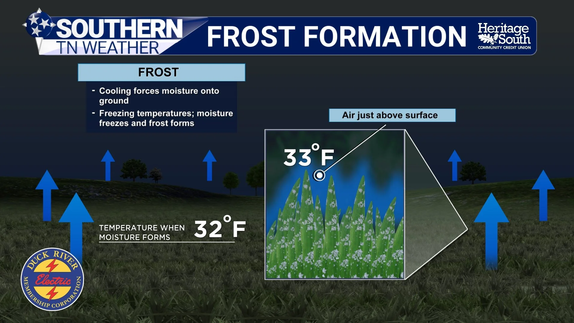
Let's start with something most of us have experienced at least once. You wake up on a chilly November morning, look outside, and notice a thin coating of white ice crystals covering your lawn, vehicle, or rooftop. Naturally, you check the temperature, expecting to see something below freezing. But instead, your weather station says 35 degrees! Wait a minute. How in the world can frost develop if the temperature is ABOVE freezing? Well, the answer comes down to an important distinction between the temperature of the air and the temperature of the surfaces around us.
When meteorologists report an official air temperature, that measurement is generally taken approximately five feet above the ground in a properly ventilated, shaded enclosure. However, the temperature of your grass, vehicle windshield, or other exposed surfaces can be considerably different from the air temperature measured several feet above them. During clear, calm nights, the ground and other exposed surfaces lose heat through a process called radiational cooling. Throughout the day, these surfaces absorb energy from the sun. Once the sun goes down, they begin releasing that energy back into the atmosphere and eventually into space. When skies are clear, that heat can escape rather efficiently, and when winds are light, there isn't much atmospheric mixing to continually replace the colder air near the surface with slightly warmer air from above.
As a result, exposed surfaces can become several degrees colder than the surrounding air. For example, let's say the official air temperature in Shelbyville is 35 degrees. Your lawn, however, may have cooled to 30 degrees. If there's enough moisture in the air, water vapor can deposit directly onto those below-freezing surfaces as tiny ice crystals, creating frost. That's why you can wake up to a frosty lawn even though your thermometer never officially reached 32 degrees! However, there's another important ingredient we need to discuss, and that's MOISTURE. Frost doesn't simply appear because a surface becomes cold. There also needs to be sufficient water vapor in the surrounding air. When a surface cools below freezing and reaches the frost point, water vapor can transition directly into ice through a process called deposition. Unlike the formation of ordinary dew, where water vapor condenses into liquid droplets, deposition allows water vapor to become ice without first passing through the liquid phase.
If the air is extremely dry, a surface can fall below freezing without developing much visible frost at all. And that brings us to something important: Just because you don't SEE frost doesn't mean temperatures haven't fallen below freezing! This is particularly important during strong cold outbreaks when the atmosphere may be extremely dry, allowing temperatures to fall well below freezing without producing the thick coating of frost we sometimes associate with cold mornings.
Light Freeze vs. Hard Freeze: Why Does 28 Degrees Matter?
Now that we've discussed frost, let's move on to freezing temperatures. A freeze occurs when the air temperature itself falls to 32 degrees or lower. Unlike frost, which depends on the temperature of individual surfaces and the availability of moisture, a freeze is determined by the actual air temperature. However, not all freezes are created equal. Meteorologists commonly distinguish between a light freeze and a hard freeze because the intensity and duration of freezing temperatures can have very different impacts on vegetation. A light freeze generally refers to temperatures falling just below freezing, often somewhere between 29 and 32 degrees. During a light freeze, sensitive plants may experience damage, particularly if temperatures remain below freezing for several hours. However, some vegetation can tolerate brief periods of light freezing temperatures, especially if the plants have already begun adapting to cooler fall weather.
A hard freeze is a different story. A hard freeze is commonly defined as temperatures reaching 28 degrees or lower, particularly when those temperatures persist long enough to cause substantial damage to vegetation. While specific thresholds can vary, 28 degrees is a widely recognized benchmark. But why is that temperature so important? As temperatures fall below freezing, ice can begin forming within and around plant tissues. The freezing process can pull water out of plant cells, causing dehydration and damaging delicate cellular structures. In some circumstances, ice formation inside cells can cause even more severe damage. The colder the temperature and the longer the exposure, the greater the potential for significant injury.
For example, a brief dip to 31 degrees might damage some sensitive flowers or vegetables but leave many other plants relatively unaffected. However, several hours with temperatures in the middle 20s could cause much more extensive damage, particularly to plants that haven't fully adapted to colder conditions. Of course, the exact impact depends on the type of vegetation. Some plants are remarkably cold-hardy and can survive temperatures well below freezing, while others can experience damage even before the air temperature officially reaches 32 degrees. And here's something else worth mentioning. A hard freeze does NOT automatically mean everything outside is going to die. Established trees, dormant perennials, and cold-hardy vegetation are generally much better equipped to handle freezing temperatures than tender annuals or warm-season plants. Nevertheless, a widespread hard freeze is often an important turning point in the fall season because it can effectively bring an end to the growing season for many types of vegetation.
One of the most interesting aspects of forecasting frost and freezing temperatures across Southern Middle Tennessee is how dramatically temperatures can vary from one community to another. Believe it or not, two locations separated by only a few miles can experience completely different overnight temperatures, especially when skies are clear and winds become light. For example, imagine a weather station on a hilltop near Deason reporting a temperature of 33 degrees while a sheltered valley near Normandy has already fallen to 26 degrees. How can that happen when the two locations are so close together? The answer involves something meteorologists call cold-air drainage.
Cold air is denser than warm air, and when winds become light, that colder air can gradually move downhill and collect in valleys, hollows, and other low-lying areas. This process can create pockets of especially cold temperatures near the surface, even while nearby hilltops remain several degrees warmer. It's one of the reasons our sheltered valleys around Normandy, Bell Buckle, Wartrace, and other portions of Bedford County can experience freezing temperatures before some of our more elevated communities. And it's certainly not limited to Bedford County! Similar temperature differences can occur across Maury, Marshall, Coffee, Franklin, Lincoln, and Moore counties, particularly in areas with varied terrain. The Cumberland Plateau adds another layer of complexity because its higher elevation generally favors cooler temperatures, but individual valleys and exposed ridges can behave quite differently during clear, calm nights.
This is also why I always caution against relying exclusively on a single weather station when evaluating frost and freeze potential. Just because the official temperature in Shelbyville is 34 degrees doesn't necessarily mean your backyard in a nearby sheltered valley is experiencing the same conditions. Local geography matters, sometimes A LOT! Cloud cover and wind also play important roles. Clouds can absorb and re-emit infrared radiation, reducing how quickly the ground loses heat overnight. Meanwhile, stronger winds can mix the lower atmosphere, preventing the coldest air from becoming concentrated immediately near the surface. That's why a clear, calm night with temperatures in the lower 30s can sometimes produce more widespread frost than a cloudy, breezy night with similar air temperatures. However, during a particularly strong cold outbreak, freezing temperatures can develop even with some wind. In those situations, the entire lower atmosphere may be cold enough to support a freeze, rather than relying primarily on nighttime radiational cooling.
What Does This Mean for Our Growing Season?
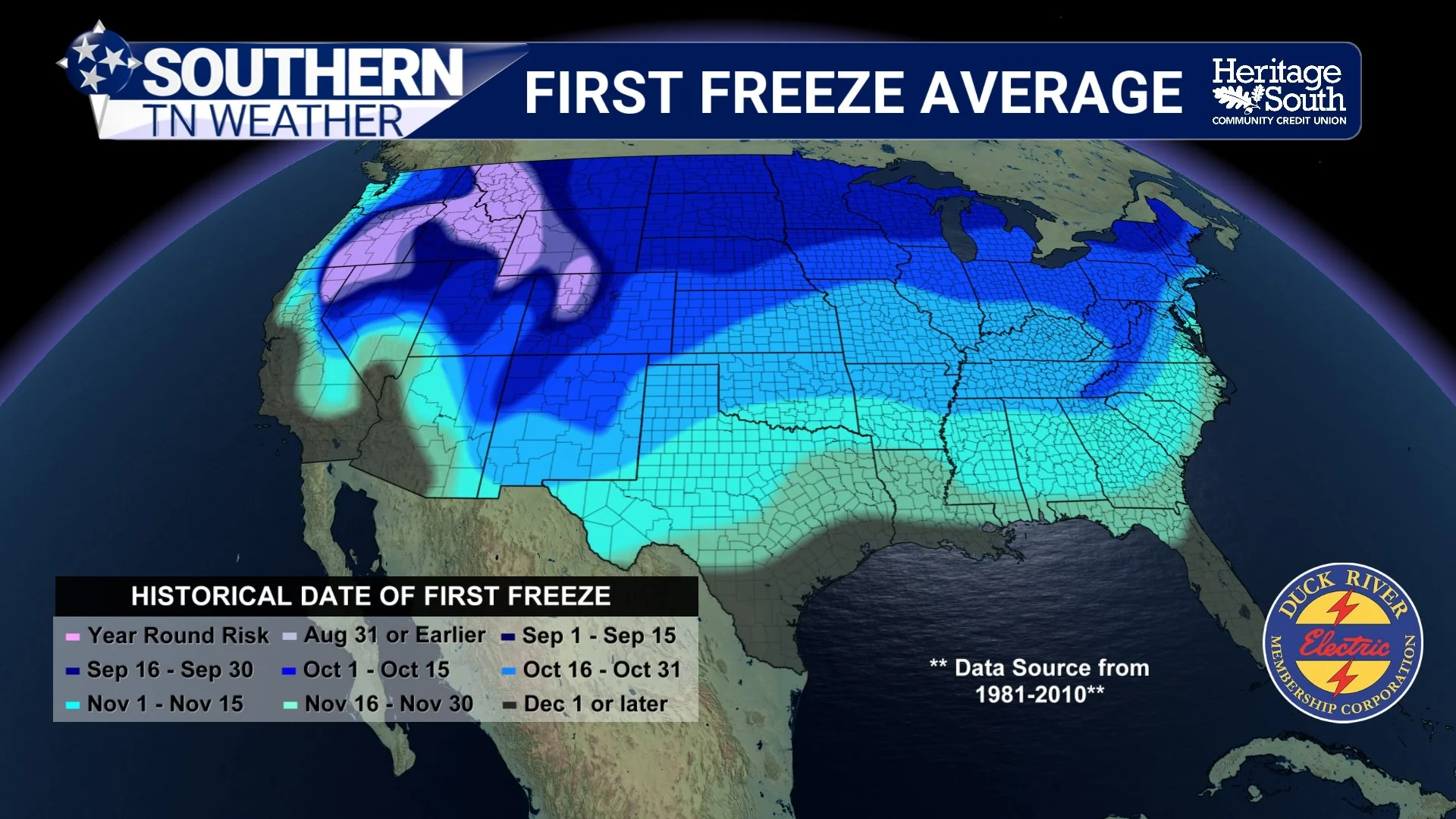
Every fall, we eventually reach a point where temperatures become cold enough to end the growing season for much of our region. However, determining when that happens isn't quite as simple as looking for the first morning when temperatures reach 32 degrees. That's because a brief, light freeze doesn't necessarily kill all vegetation. Some plants may experience only minor damage, while others may continue growing once temperatures warm back up. A hard freeze, especially one involving several hours of temperatures at or below 28 degrees, is much more likely to cause widespread damage to remaining tender vegetation. That's why we've been paying particularly close attention to the possibility of our first widespread hard freeze this weekend.
We've already experienced some frosty mornings and localized freezing temperatures across Southern Middle Tennessee this fall. However, the upcoming cold outbreak looks considerably more substantial, with temperatures potentially falling into the middle to upper 20s across much of our region. If those temperatures materialize, we'll likely be able to declare the growing season effectively over across a large portion of Southern Middle Tennessee. Of course, that doesn't mean all plant growth immediately stops or that every type of vegetation is killed. Many cold-hardy plants remain active through portions of the winter, and some perennial vegetation simply enters dormancy until warmer temperatures return. But for many warm-season plants, this could be the event that finally brings the growing season to an end.
Now, here's something else I want to address because I know it can cause confusion. You may have noticed that despite our recent frosty mornings and the potential for freezing temperatures this weekend, there haven't been any official Frost Advisories, Freeze Watches, or Freeze Warnings issued for Southern Middle Tennessee. That doesn't mean freezing temperatures aren't expected! The National Weather Service Nashville office ends its seasonal frost and freeze headline program on October 1. After that date, those particular advisories and warnings are no longer routinely issued because the growing season is considered to have reached its seasonal endpoint for the purposes of the warning program.
However, the atmosphere doesn't pay attention to the calendar! We can absolutely experience damaging freezing temperatures after October 1, even without an official Frost Advisory or Freeze Warning being issued. That's why it's important to continue monitoring temperature forecasts and taking precautions when necessary, regardless of whether an official frost or freeze headline appears. And with the cold weather approaching this weekend, I would strongly encourage anyone with sensitive outdoor vegetation to begin making preparations now.
Our First Widespread Hard Freeze Is Looking Increasingly Likely!
Now, let's bring all of this back to our actual forecast for Southern Middle Tennessee, because we've got some BIG changes coming over the next several days! We're enjoying one final relatively warm afternoon today, with temperatures climbing into the lower to middle 70s across much of our region. However, a strong cold front will approach from the northwest later this afternoon and evening, bringing increasing cloud cover, breezy southwest winds, and the opportunity for scattered showers and thunderstorms. The main window for showers and storms across Southern Middle Tennessee looks to be between approximately 7 PM and 11 PM this evening, although a few showers could develop earlier across our northwestern communities. Not everyone will necessarily see rainfall, but scattered showers and a few thunderstorms will certainly be around as the front pushes eastward.
One thing we're watching is the potential for a stronger thunderstorm or two, particularly across our northwestern counties, including Maury and Marshall. The atmosphere will have some wind shear available, but instability, or storm fuel, looks rather limited. That should help keep the overall severe weather threat LOW, although a stronger storm capable of producing gusty winds cannot be completely ruled out. The greatest concern with any stronger storms would be damaging wind gusts, with the better opportunity for stronger activity generally favoring areas farther north and west of Southern Middle Tennessee. Most of tonight's activity should move east of our region by around midnight, although the atmosphere won't completely settle down just yet.
Behind the front, a deep upper-level trough will establish itself across the eastern United States, allowing a MUCH colder air mass to spread southward into Tennessee. Thursday will be noticeably cooler, with afternoon highs generally in the middle to upper 50s across much of our region, roughly 10–15 degrees colder than today. Northwest winds will add an additional chill to the air, and a few scattered showers could develop during the afternoon and evening as another disturbance rotates through the larger upper-level trough. By Friday, temperatures will struggle even more, with afternoon highs generally remaining in the 40s across much of Southern Middle Tennessee. Some of our colder communities and higher elevations may have difficulty climbing beyond the middle 40s!
And yes, I'm still keeping an eye on the possibility of a few scattered SNOW FLURRIES along the Cumberland Plateau late Thursday night into Friday. The best opportunity would be across the higher elevations of Grundy County, including Monteagle, Sewanee, and Altamont, where colder temperatures and lingering moisture could support a few passing flurries or a brief mix of rain and snow. However, I want to emphasize that I'm NOT expecting any meaningful snowfall accumulations or travel impacts. In fact, many communities may not see a single snowflake, especially as you move westward off the Plateau.
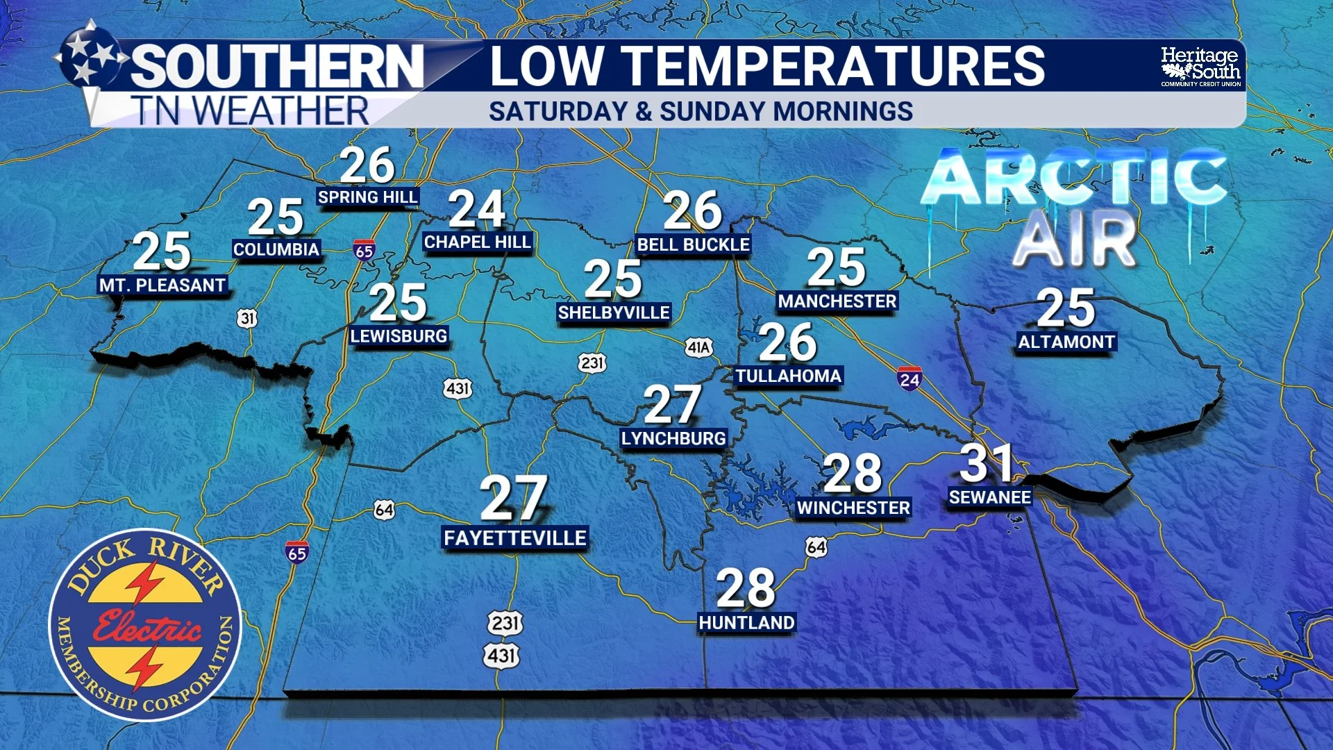
But the main event arrives Friday night into Saturday morning. Current forecast guidance continues to support widespread overnight lows in the 20s across Southern Middle Tennessee, with many communities potentially falling into the middle to upper 20s. Some of our colder valleys could dip a little lower, depending on cloud cover and wind conditions. That would be more than cold enough to support our first widespread HARD FREEZE of the season! And unfortunately for anyone hoping this will be a one-night event, another round of temperatures in the 20s looks likely Saturday night into Sunday morning.
Saturday and Sunday should feature generally dry conditions as the upper-level trough gradually shifts eastward. However, afternoon temperatures will remain chilly, with highs primarily in the 50s and perhaps a few communities struggling to get much beyond the upper 40s. That means we could experience TWO consecutive mornings with widespread freezing temperatures, giving sensitive vegetation very little opportunity to recover between cold nights. Now, exact temperatures will still depend on factors such as cloud cover, wind speeds, and local geography. Some sheltered valleys could become colder than surrounding communities, while locations with more wind or lingering cloud cover may remain a few degrees warmer. Nevertheless, confidence is HIGH that a significant freeze will occur across much of Southern Middle Tennessee this weekend.
The good news is that temperatures should gradually moderate early next week as the coldest air begins moving away from our region. Afternoon highs should slowly climb back into the 60s by the middle of next week, although overnight temperatures may remain rather chilly in the 20s and 30s. And unfortunately, despite our ongoing drought conditions, there aren't any convincing signs of a substantial rainfall event developing during the early portion of next week. But before we worry too much about that, we've got some VERY chilly November weather to get through!
The Bottom Line 🧾
Frost: Ice crystals that form on exposed surfaces when those surfaces cool below freezing and sufficient moisture is available. Frost can develop even when the official air temperature is above 32 degrees.
Light Freeze: Air temperatures generally between 29 and 32 degrees. Sensitive vegetation can experience damage, particularly with prolonged exposure.
Hard Freeze: Temperatures reaching 28 degrees or lower, especially for an extended period. This can cause significant damage to many types of vegetation.
Why temperatures vary: Sheltered valleys and low-lying communities can become several degrees colder than nearby hilltops because of cold-air drainage.
Wednesday afternoon: Mild and breezy, with highs in the lower to middle 70s and increasing clouds ahead of an approaching cold front.
Wednesday evening: Scattered showers and thunderstorms, mainly between 7 PM and 11 PM. A stronger storm with gusty winds cannot be ruled out, particularly across our northwestern counties.
Thursday: MUCH cooler, with highs in the middle to upper 50s. Additional scattered showers are possible during the afternoon and evening.
Friday: COLD! Afternoon highs generally in the 40s, with a few lingering showers possible, especially along the Cumberland Plateau.
Snow flurries? A few flurries or a brief rain/snow mix could occur across the Cumberland Plateau late Thursday night into Friday. No accumulations or travel impacts are expected.
Friday night into Saturday morning: Our first widespread HARD FREEZE of the season is likely, with lows falling into the 20s across much of Southern Middle Tennessee.
Saturday night into Sunday morning: Another round of widespread freezing temperatures is likely.
Growing season: This weekend's hard freeze could effectively bring the growing season to an end across much of our region.
Early next week: Dry weather continues, with temperatures gradually moderating and highs returning to the 60s by the middle of the week.
Important reminder: Frost Advisories and Freeze Watches/Warnings are no longer routinely issued locally after October 1, but freezing temperatures can still occur!
📰 Reminder: The Southern Tennessee Weather Blog, presented by Heritage South Community Credit Union, is updated Monday through Friday with fresh, locally tailored forecasts you can trust
