

The Southern Tennessee Weather Blog is proudly presented by Heritage South Community Credit Union.
We Help When Others Won’t!
Visit https://www.heritagesouth.org/ today to see how HSCCU can help YOU!
After a rather active start to November, it looks like Mother Nature is finally getting ready to give us a break! We've gone from weeks of unusually warm and dry weather to TWO rounds of widespread rainfall in just a matter of days, and while the additional moisture has certainly been welcome, I think most of us are ready to see a little sunshine again. Well, I've got some GOOD NEWS! Once our current storm system moves out of Southern Middle Tennessee later today, we're looking at an extended stretch of dry weather that could last well into next week. However, there are a few changes on the way, including a noticeable drop in temperatures, some potentially frosty mornings, and an interesting signal in the longer-range outlooks that could have implications for our ongoing drought.
First, let's talk about the system currently moving through our region. As of Wednesday afternoon, a cold front is pushing eastward across Middle Tennessee, bringing the final round of showers and thunderstorms through our area. The atmosphere has managed to develop just enough instability ahead of the front to support a few stronger thunderstorms, particularly across our eastern communities and portions of the Cumberland Plateau. While the overall severe weather threat remains LOW, a few storms could still produce damaging wind gusts and locally heavy rainfall before the front clears our region. The threat for a brief tornado also remains very low, but not completely zero. Thankfully, the cold front is moving along at a fairly good pace, and I expect the remaining precipitation to gradually come to an end from west to east through the afternoon and early evening.
Once the front passes, we'll begin noticing a fairly significant change in the air mass across Southern Middle Tennessee. Winds will gradually shift toward the west and northwest, allowing cooler and drier air to move into our region. Dew points, which have been running in the 60s ahead of the front, will fall into the 40s by Thursday morning. That's a pretty substantial drop in atmospheric moisture, and it will help put an end to our recent stretch of unsettled weather. Skies should also gradually begin clearing overnight, although there's one thing we'll need to watch early Thursday morning: FOG! With all the recent rainfall leaving the ground rather wet, clearing skies and lighter winds could create favorable conditions for patchy fog development, especially in our valleys and other sheltered locations. Some of that fog could become locally dense, so keep that in mind if you're heading out early Thursday morning.
Sunshine Returns, but Temperatures Are Heading Down!
Thursday is shaping up to be a MUCH quieter day across Southern Middle Tennessee. Once any morning fog burns off, we should enjoy a mixture of sunshine and a few passing clouds, with afternoon temperatures generally climbing into the middle to upper 60s. A few of our warmer southern communities could approach 70 degrees, while the Cumberland Plateau will likely remain a little cooler. That's certainly going to feel different from the middle to upper 70s we experienced earlier this week! More importantly, widespread rainfall is NOT expected, and that dry weather should continue through the remainder of the workweek.
Friday will bring another subtle change as a weak disturbance moves through the atmosphere above our region. Normally, when we talk about an upper-level disturbance approaching, that raises questions about rain chances. However, this particular system will have very little atmospheric moisture available to work with. As a result, I'm not expecting any meaningful precipitation from it. Instead, we'll likely notice a few additional clouds and perhaps some breezy conditions as the disturbance passes through. Winds could occasionally gust around 15–20 MPH, particularly across our southern communities, but otherwise Friday should remain dry. Afternoon highs will generally reach the lower to middle 60s, with some southern locations potentially climbing a little higher.
The more noticeable change arrives Friday night into Saturday as another push of cooler air moves into Southern Middle Tennessee. This will be associated with a broader trough of low pressure developing across the eastern United States. Unlike the storm system moving through today, this trough won't have much moisture to work with locally. Instead, its primary impact will be to transport colder air southward, giving us a more substantial taste of November weather.
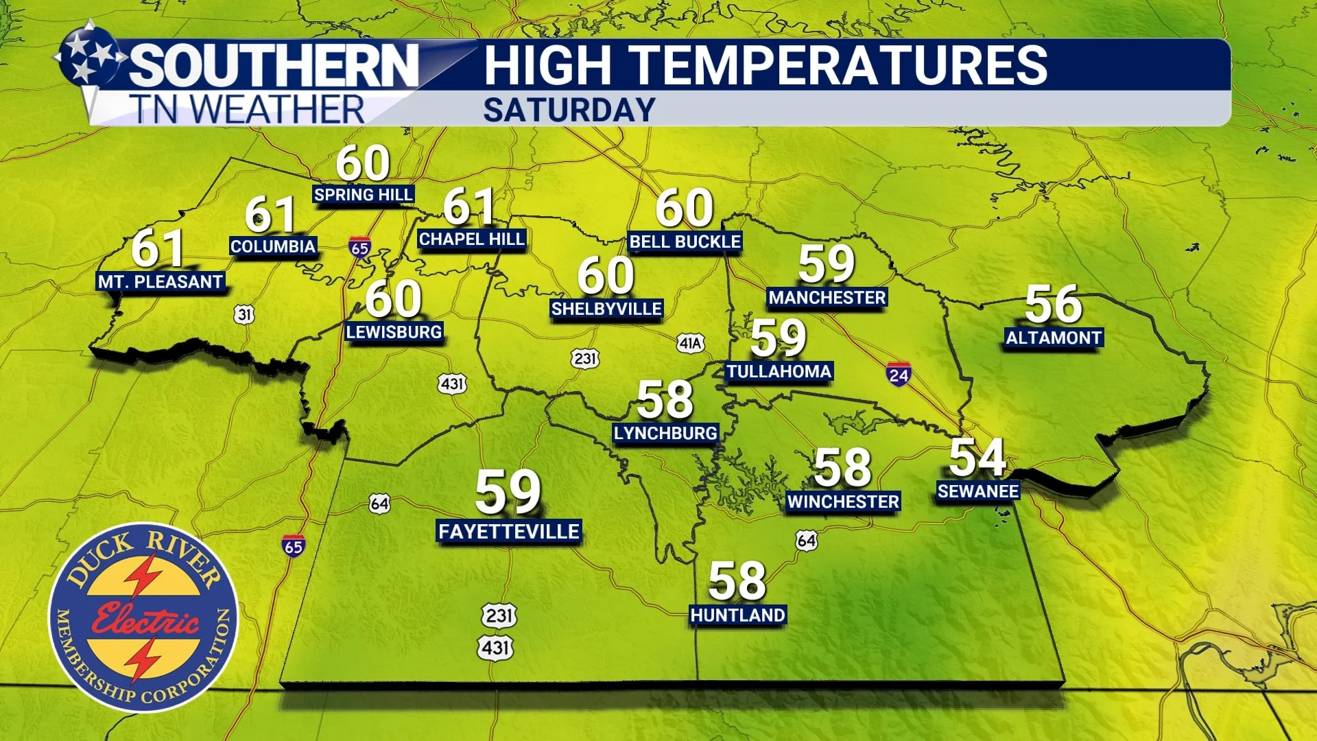
By Saturday afternoon, temperatures may struggle to climb beyond the middle to upper 50s across much of our region. Some of our southern communities could reach the lower 60s, but the overall trend will be toward noticeably cooler conditions. And if you've been enjoying those unusually warm afternoons we've experienced throughout much of October, Saturday may come as a bit of a shock!
But the REALLY interesting part of the forecast arrives Saturday night into Sunday morning.
Could We See Our First Widespread Freeze of the Season?
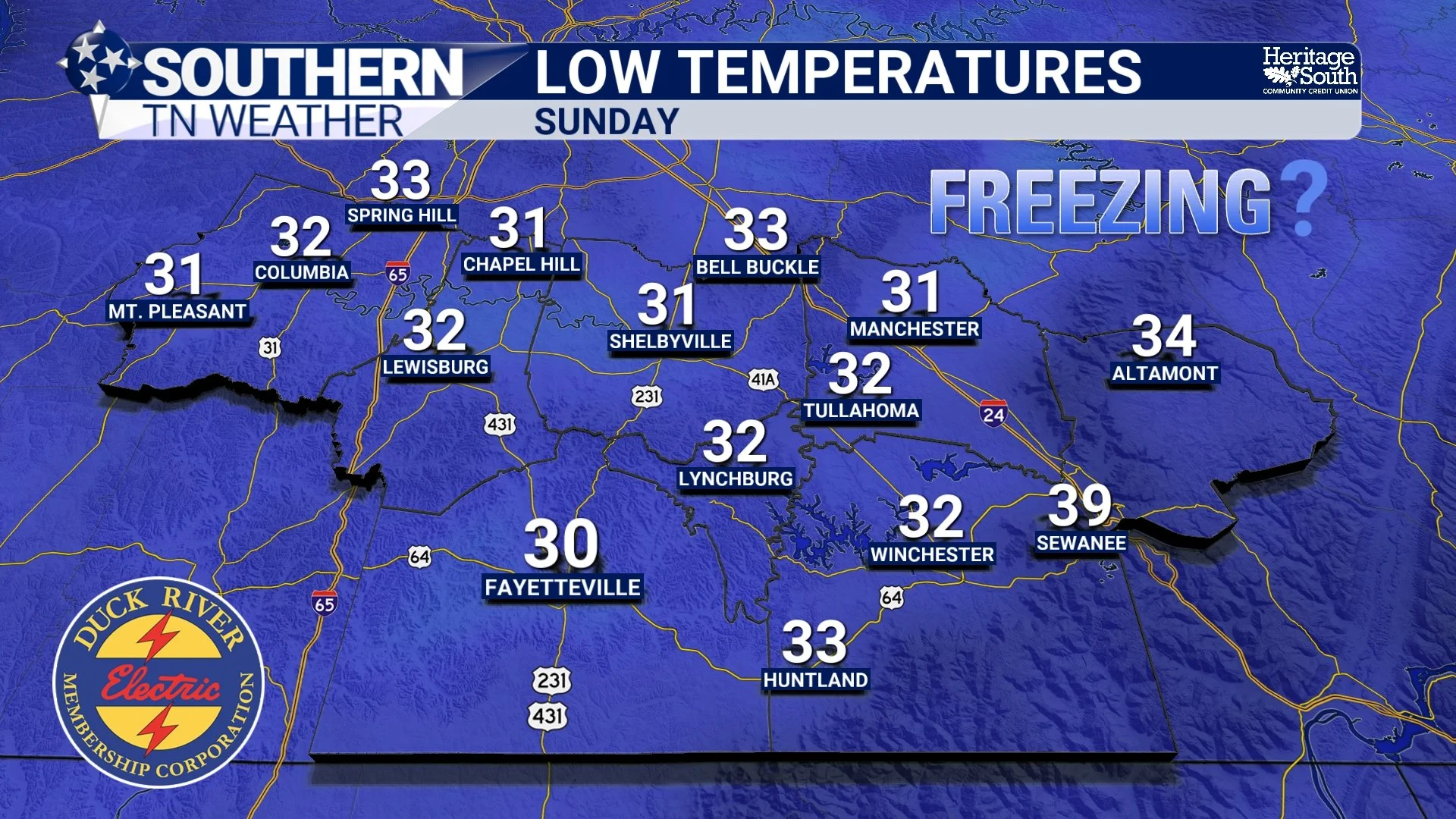
With a colder air mass settling across Southern Middle Tennessee and skies expected to remain mostly clear, temperatures could fall rather quickly Saturday evening. If winds become sufficiently light overnight, some communities could experience their coldest temperatures of the season so far.
Current guidance suggests that overnight lows could fall into the lower to middle 30s across much of our region, with some of our colder valleys and sheltered locations potentially dipping into the upper 20s. The Cumberland Plateau will also have an opportunity to experience temperatures near or below freezing.
That means FROST and potentially FREEZING temperatures are becoming legitimate concerns for Saturday night into Sunday morning!
Now, there are still a few details that need to be worked out. The amount of cloud cover, wind speeds, and the exact strength of the incoming cold air will all influence how low temperatures ultimately fall. If winds remain a little stronger overnight, that could limit frost formation in some communities. On the other hand, if skies clear completely and winds become calm, temperatures could fall a little lower than currently forecast, especially in our colder valleys and hollows.
This is also a good opportunity to remember that frost and freezing temperatures aren't necessarily the same thing. Frost can develop on exposed surfaces even when the official air temperature, measured several feet above the ground, remains slightly above freezing. That's why sensitive plants can sometimes experience frost damage even when your thermometer never quite reaches 32 degrees.
If you've still got sensitive outdoor plants that you want to keep around a little longer, I'd recommend paying close attention to the forecast over the next couple of days. We should have a much better idea of just how widespread the freezing potential will become as we get closer to Saturday night.
The good news is that our chilly weather won't necessarily last forever. Temperatures should gradually begin moderating Sunday into early next week, with afternoon highs climbing back into the lower to middle 60s. Overnight temperatures will likely remain rather chilly, however, with lows generally in the 30s.
And throughout this entire period, rainfall chances look VERY LOW!
What Does the Climate Prediction Center Say About the Rest of November?
Now, here's where our forecast gets particularly interesting, especially considering the drought conditions we've been dealing with across Southern Middle Tennessee.
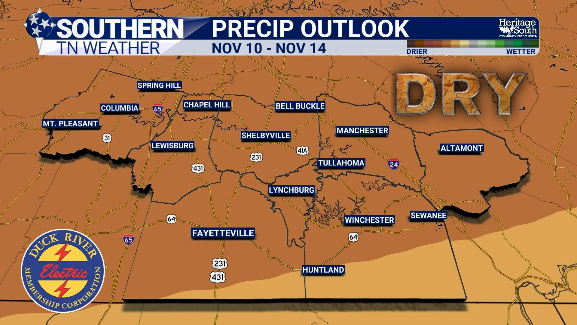
After finally receiving some much-needed rainfall over the past several days, you might be wondering whether our weather pattern is going to remain active. Unfortunately, the latest longer-range guidance suggests that another relatively dry stretch could be developing.
The Climate Prediction Center's latest 6–10 day outlook, valid November 9–13, favors above-normal temperatures and below-normal precipitation across Tennessee. That's a pretty significant change from the wetter pattern we've experienced during the opening days of November.
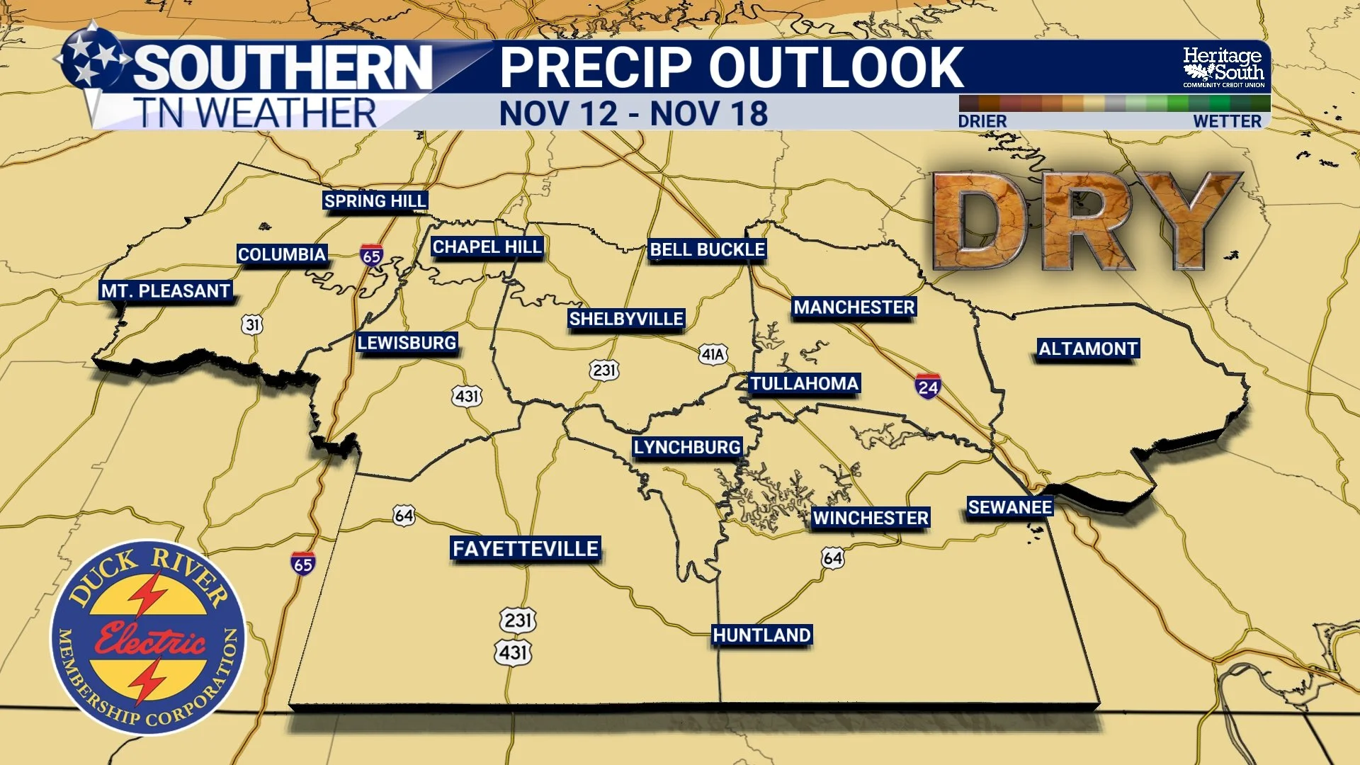
And when we look even farther ahead, the 8–14 day outlook, valid November 11–17, continues to favor above-normal temperatures and below-normal precipitation across our state.
Now, I want to emphasize something important about these outlooks. They are NOT predicting that it won't rain at all during those periods. Instead, they indicate that the odds favor receiving less precipitation than what we would normally expect during that time of year. It's entirely possible that we could still experience a passing shower or even another storm system during that timeframe. However, the overall pattern currently appears more favorable for relatively dry conditions than for widespread, repeated rainfall events.
The same concept applies to the temperature outlook. Above-normal temperatures don't necessarily mean we're heading back into the 80s. Remember, our average temperatures are gradually declining as we move deeper into November. A day with highs in the upper 60s or lower 70s could still qualify as above normal later in the month.
One of the reasons for this longer-range pattern is the expected positioning of the jet stream across North America. Forecast guidance suggests that a more pronounced ridge of high pressure may develop across portions of the central United States, while the more active storm track becomes focused farther west. Meanwhile, weak troughing may persist across portions of the Southeast.
This type of setup can make it more difficult for organized storm systems to deliver widespread rainfall to Southern Middle Tennessee. However, the exact positioning and strength of these atmospheric features will determine whether our region experiences completely dry weather or occasional passing disturbances.
And as we've discussed in previous educational blogs, the farther into the future we look, the more uncertainty becomes involved. These longer-range outlooks are useful for identifying broad trends, but they aren't designed to predict the exact weather conditions for individual days.
What Does This Mean for Our Ongoing Drought?
This is probably the biggest concern I have when looking at the extended forecast. The rainfall we've received over the past several days has certainly been beneficial. After weeks of watching drought conditions deteriorate across Southern Middle Tennessee, finally getting multiple rounds of precipitation is exactly what we needed. The additional moisture will help replenish the upper layers of soil, benefit vegetation and pastures, and temporarily reduce some of the immediate concerns associated with our prolonged dry spell.
However, our drought developed over an extended period, and it isn't going to disappear after just a couple of rainfall events. Some of our deeper soil moisture deficits, groundwater levels, and other longer-term indicators may take considerably more time to recover.
That's why the possibility of another extended dry stretch is worth watching. If we go another week or two with very little meaningful precipitation, some of the benefits from our recent rainfall could gradually diminish, particularly if temperatures trend above normal. Warmer weather can increase evaporation and help dry out the upper layers of soil, although the rate of drying will also depend on humidity, wind speeds, sunshine, and vegetation.
Now, I don't want anyone to interpret this as a prediction that our drought is about to rapidly worsen again. We've finally received some beneficial rainfall, and that's a positive development. But it does mean we need to continue monitoring the longer-range pattern rather than assuming that a couple of wet days have completely solved our moisture problems.
The next official drought assessments will also help us better understand how much improvement has occurred across Southern Middle Tennessee. Keep in mind that the U.S. Drought Monitor considers several different indicators, and improvements don't always show up immediately after a rainfall event. For now, I'm encouraged by the rain we've received, but I'll be watching closely to see whether additional opportunities develop later in November.
The Bottom Line 🧾
Wednesday afternoon: Showers and thunderstorms gradually move out from west to east as a cold front crosses Southern Middle Tennessee. A LOW severe weather threat continues ahead of the front, especially across eastern communities.
Wednesday night: Rain ends, skies gradually clear, and temperatures fall into the middle 40s to lower 50s. Patchy fog may develop overnight.
Thursday: MUCH quieter weather! Morning fog gives way to partly sunny skies, with highs generally in the middle to upper 60s.
Friday: Dry conditions continue, with a few additional clouds and occasional breezy conditions. Highs generally in the lower to middle 60s.
Saturday: A noticeable cooldown arrives! Afternoon highs mainly in the middle to upper 50s, with some southern communities reaching the lower 60s.
Saturday night: FROST and FREEZING temperatures are possible, with lows generally in the lower to middle 30s. Some colder valleys and higher elevations could dip into the upper 20s.
Sunday into early next week: Dry weather continues, with highs gradually returning to the lower to middle 60s. Chilly mornings remain likely.
November 9–13: The Climate Prediction Center favors above-normal temperatures and below-normal precipitation across Tennessee.
November 11–17: The longer-range outlook continues to favor a relatively warm and dry pattern.
Drought outlook: Recent rainfall has been beneficial, but another extended dry stretch could slow further drought recovery
📰 Reminder: The Southern Tennessee Weather Blog, presented by Heritage South Community Credit Union, is updated Monday through Friday with fresh, locally tailored forecasts you can trust
