

The Southern Tennessee Weather Blog is proudly presented by Heritage South Community Credit Union.
We Help When Others Won’t!
Visit https://www.heritagesouth.org/ today to see how HSCCU can help YOU!
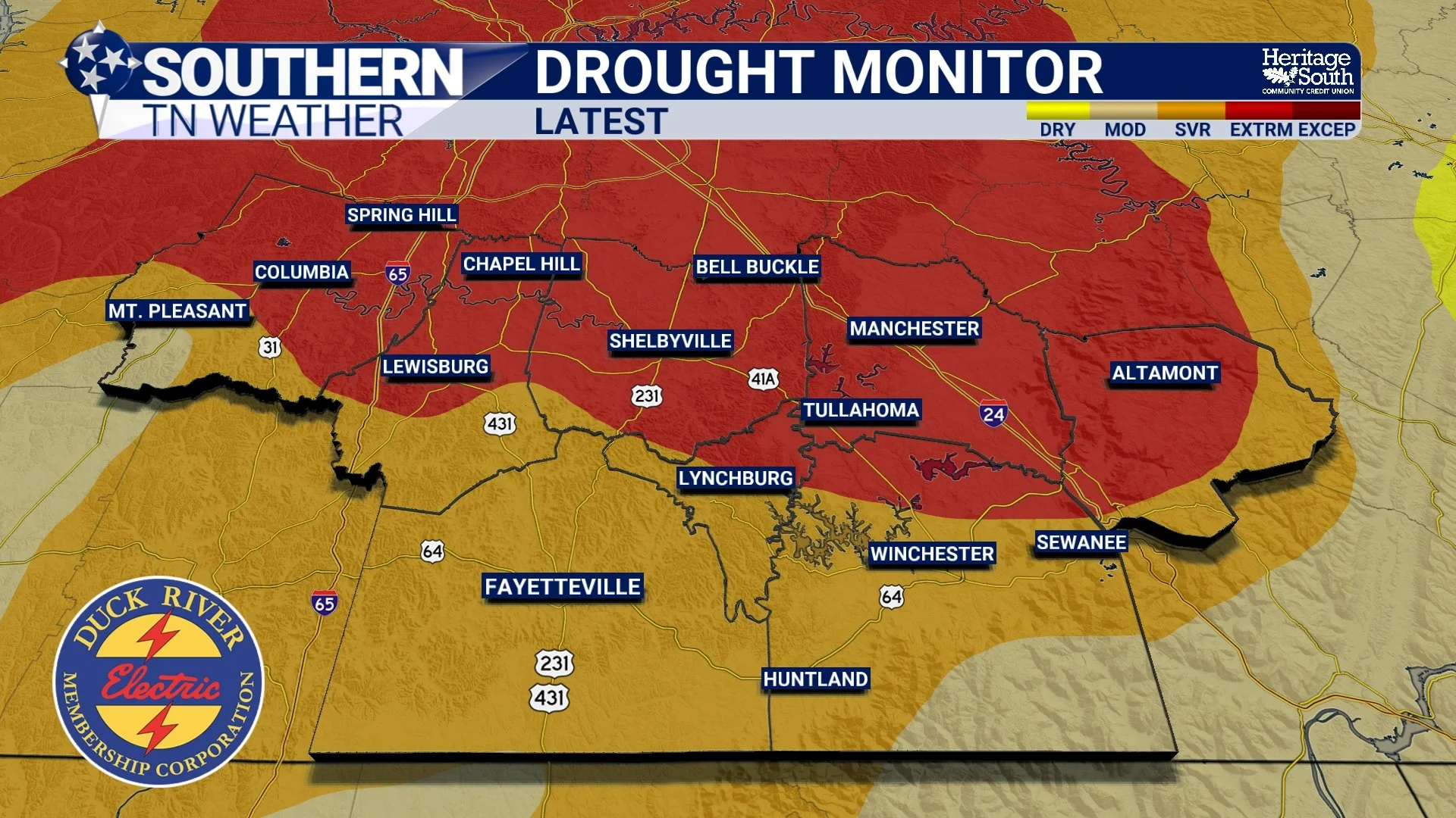
After weeks of watching drought conditions steadily worsen across Southern Middle Tennessee, I've FINALLY got a little bit of encouraging news to share! The latest U.S. Drought Monitor, released Thursday morning, shows some improvements across portions of our southern counties following the rainfall we received over the weekend. While those improvements are certainly welcome, I want to make one thing VERY clear: We still have a LONG way to go before our drought is over.
In fact, Extreme Drought (D3) continues across much of Middle Tennessee, with Severe Drought (D2) affecting additional portions of the region. Some of our communities have experienced significant rainfall deficits over the past several months, and even though we've finally seen a more active weather pattern develop, it will take more than a couple of rainy days to completely reverse those conditions.
However, there's something particularly important about this week's Drought Monitor that I want everyone to understand. THE LATEST DROUGHT MONITOR DOES NOT INCLUDE THE RAINFALL WE RECEIVED WEDNESDAY, NOVEMBER 4! The U.S. Drought Monitor uses a Tuesday morning data cutoff, meaning the latest map reflects conditions through the morning of November 3. While Sunday's rainfall was available for consideration, Wednesday's widespread soaking arrived too late to be incorporated into this week's assessment.
That's an important distinction because some communities across Southern Middle Tennessee received substantial rainfall Wednesday, and those totals could potentially lead to additional improvements when next week's Drought Monitor is released. However, those improvements are not guaranteed, and the extent of any changes will depend on several factors beyond rainfall totals alone.
Where Have Drought Conditions Improved?
Let's start with the good news. According to the latest drought assessment, portions of southern Middle Tennessee experienced some improvement over the past week, particularly in counties that received more substantial rainfall during our first storm system over the weekend. These improvements are encouraging because they represent one of the first signs that our recent rainfall is beginning to make a difference.
However, the overall drought picture remains concerning. Extreme Drought continues across much of Middle Tennessee, with Severe Drought affecting additional communities. Moderate Drought and Abnormally Dry conditions are also present across portions of our region, including areas closer to the Cumberland Plateau.
The improvement hasn't been uniform, either. Some communities received considerably more rainfall than others over the weekend, which means the benefits have varied from one location to another. Areas that picked up a more substantial soaking were better positioned to experience improvements, while locations that missed out on the heavier rainfall may have seen little change in their drought classification.
It's also important to remember that drought classifications represent more than just how much rain fell over the past several days. The U.S. Drought Monitor incorporates a variety of indicators, including precipitation deficits, soil moisture, streamflow, groundwater conditions, and reported impacts. That's why a location can receive a fairly substantial rainfall event and still remain classified in Severe or Extreme Drought. In other words, the rain we've received is helping, but we're still dealing with the effects of a prolonged dry period.
Wednesday's Rainfall Could Make a Difference Next Week
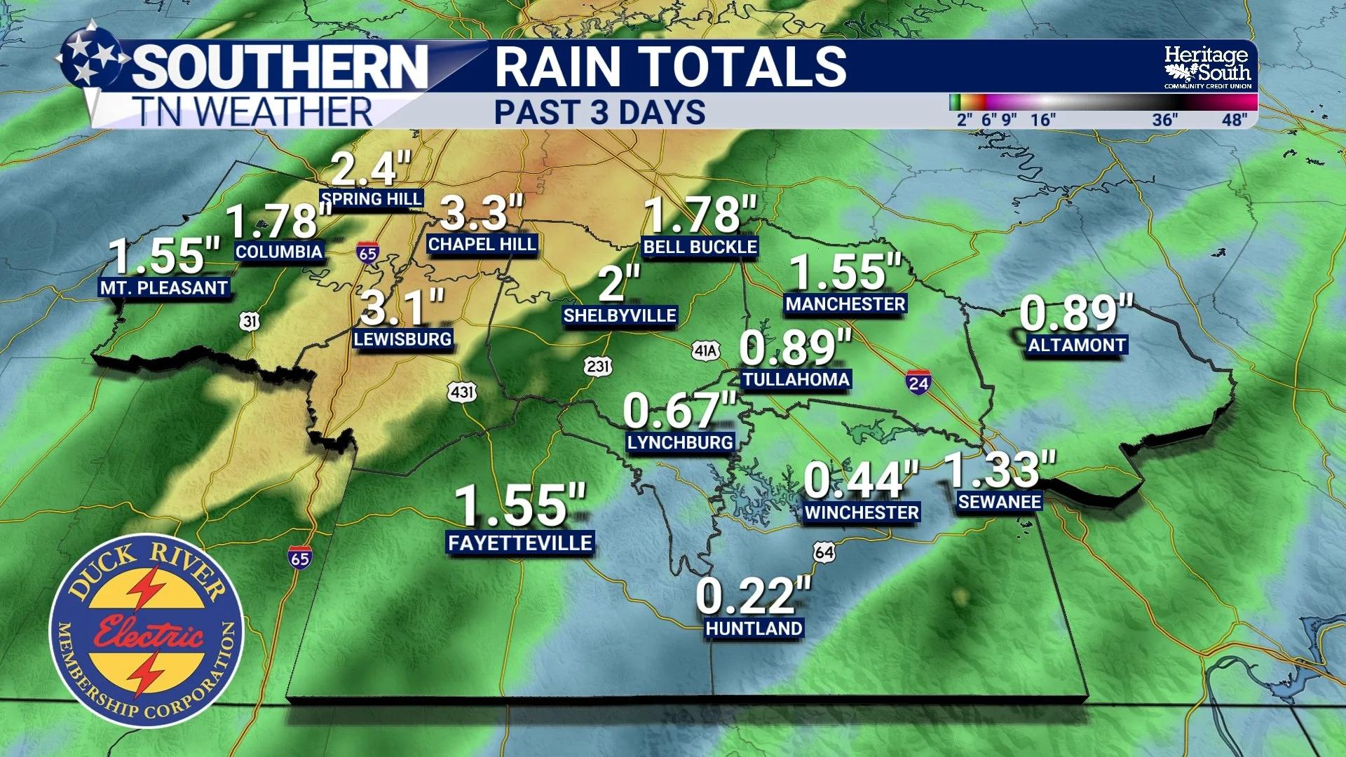
Now, let's talk about what I believe is the most encouraging part of our current situation. As many of you know, another widespread area of rain and thunderstorms moved through Southern Middle Tennessee Wednesday, bringing additional beneficial rainfall to much of our region. Some communities experienced periods of moderate to heavy rain, and when we combine those totals with what fell over the weekend, we've finally started making progress toward addressing some of our accumulated rainfall deficits.
But again, NONE OF WEDNESDAY'S RAINFALL IS REFLECTED IN THE DROUGHT MONITOR RELEASED TODAY. The map you're looking at is essentially a snapshot of conditions before our second storm system arrived. That's why I don't want anyone to become discouraged if their community remains in Extreme Drought despite receiving a substantial soaking Wednesday.
The additional rainfall could help replenish moisture in the upper layers of soil, support vegetation and pastures, and improve conditions along smaller streams and creeks. In fact, the latest hydrologic assessment already indicates that streamflows have improved across portions of Tennessee following recent rainfall, with many monitoring locations reporting normal to above-normal flows for this time of year.
That's certainly encouraging! However, streamflow improvements don't necessarily mean deeper soil moisture and groundwater supplies have fully recovered. Those longer-term indicators often respond more slowly, especially after an extended period of drought. We'll have to wait until next Thursday, November 12, to see how much of Wednesday's rainfall translates into additional changes on the official drought map. I'm hopeful we'll see more improvements across Southern Middle Tennessee, but it's important not to get ahead of ourselves.
Why Isn't a Couple of Inches of Rain Enough to End the Drought?
This is a question I've seen quite a bit recently, and it's a reasonable one. If we've finally received several inches of rainfall over a relatively short period, why are we still dealing with drought? The answer comes down to the difference between short-term rainfall and long-term moisture deficits.
Drought doesn't develop overnight. In our case, weeks of below-normal precipitation, unusually warm temperatures, and persistent dry weather gradually depleted moisture from the soil and surrounding environment. As those conditions continued, the deficits accumulated, eventually leading to the Severe and Extreme Drought classifications we've been experiencing.
When rain finally returns, the first benefits are often seen near the surface. Dry vegetation begins receiving moisture, the upper layers of soil become wetter, and smaller streams may respond relatively quickly. However, deeper soil layers and groundwater supplies can take considerably longer to recover. Think of it like a sponge that's been sitting out in the sun for several weeks. When you first pour water onto it, the surface becomes wet, but it takes additional moisture and time for that water to penetrate deeper into the material. Our soils behave somewhat similarly, although the actual process depends on soil composition, rainfall intensity, vegetation, and how dry the ground was beforehand.
That's why a slow, steady soaking rainfall is often particularly beneficial during drought conditions. It gives water more time to infiltrate the ground rather than immediately running off into drainage systems and streams. And while the rainfall we've received over the past several days has certainly been beneficial, we still need additional precipitation over the coming weeks to make more substantial progress.
Unfortunately, Another Dry Stretch Is Developing
Now, here's the part of the forecast that isn't quite as encouraging. After finally receiving two rounds of widespread rainfall within a matter of days, our weather pattern is expected to become considerably quieter across Southern Middle Tennessee. In fact, the latest seven-day precipitation outlook from the Weather Prediction Center shows essentially NO measurable rainfall expected across Tennessee through the middle of next week.
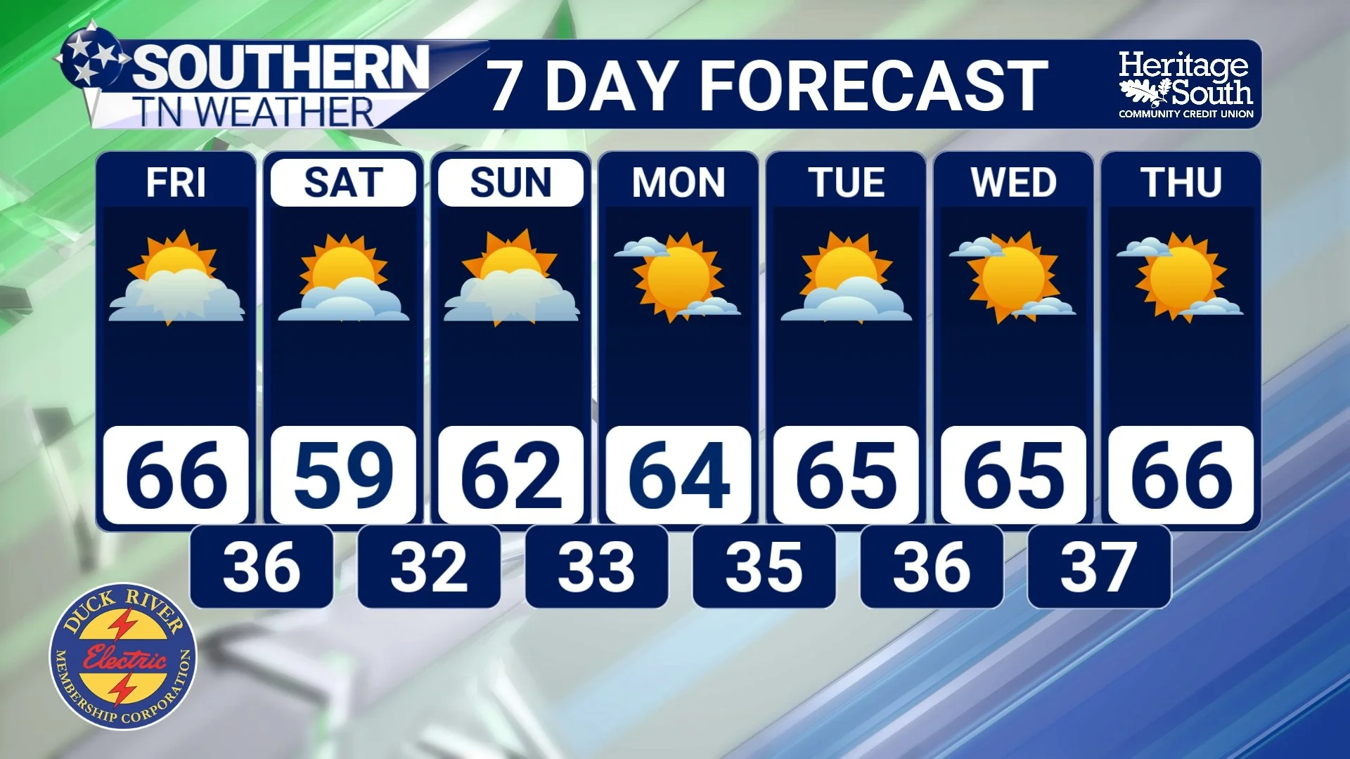
That's quite a change from what we've experienced over the past several days! High pressure and a generally drier atmospheric pattern are expected to dominate our weather through the upcoming weekend and into early next week. We'll enjoy some sunshine, cooler temperatures, and several pleasant November afternoons, but meaningful rainfall opportunities will be extremely limited.
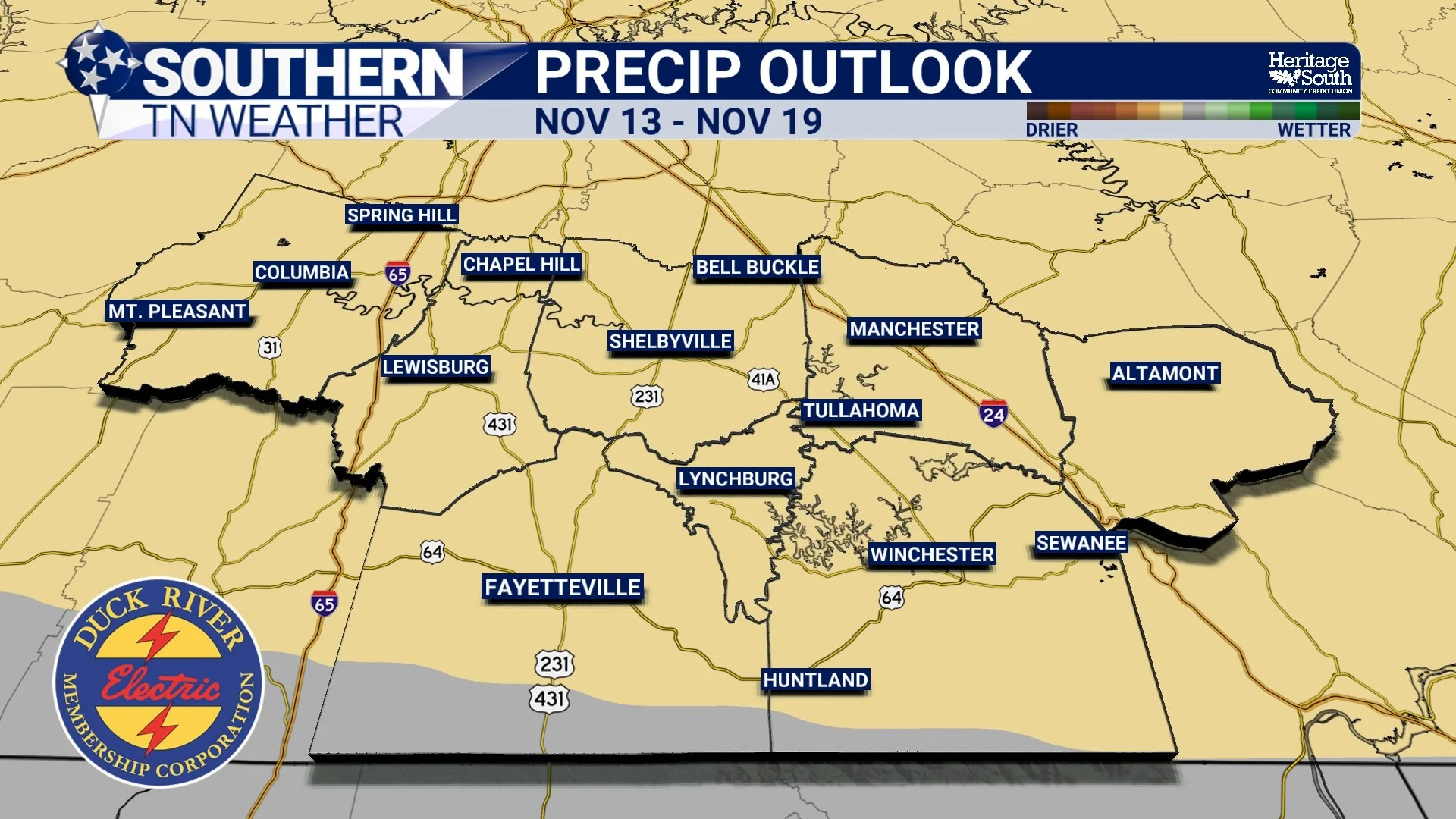
And when we look even farther ahead, the Climate Prediction Center's latest 8–14 day outlook, valid November 13–19, continues to favor a relatively warm and dry pattern across Tennessee. The outlook indicates a 50–70% probability of above-normal temperatures across the state, along with a 33–40% probability of below-normal precipitation. Those percentages represent the likelihood of temperatures and precipitation falling into their respective above-normal or below-normal categories, not the amount of warming or rainfall expected.
Now, that doesn't mean we're guaranteed to experience two completely rain-free weeks. These outlooks describe the most likely overall pattern rather than the exact weather conditions for individual days. However, they do suggest that our recent stretch of active weather may be followed by another period with relatively few opportunities for meaningful rainfall.
And that's something we'll need to monitor closely. Although the recent rainfall has helped, an extended dry stretch could slow additional drought recovery. Above-normal temperatures could also contribute to drying conditions, particularly if we experience several sunny or breezy afternoons. The good news is that temperatures will initially be considerably cooler as we head into the weekend, which should help limit moisture loss compared to the unusually warm conditions we've experienced throughout much of October.
Is There Any Hope for More Rain Later This Month?
Thankfully, the longer-range outlook isn't entirely discouraging. While the next week or two may favor relatively dry conditions, the Climate Prediction Center's seasonal outlook for November through January suggests that precipitation could average near to above normal across portions of Tennessee during the late fall and early winter months.
That's an important distinction. Just because we're expecting another dry stretch in the short term doesn't necessarily mean the remainder of November, December, and January will follow the same pattern. In fact, the latest seasonal drought outlook suggests that drought conditions are likely to persist across portions of Tennessee over the next several weeks, but gradual improvement remains possible as we move deeper into late fall and early winter.
Historically, the cooler months can provide favorable opportunities for widespread rainfall across Southern Middle Tennessee as larger storm systems move across the country. However, whether those systems actually deliver enough precipitation to improve our drought will depend on the evolving atmospheric pattern. And as always, seasonal outlooks aren't guarantees. They simply provide an indication of which temperature and precipitation patterns are more likely over an extended period. For now, I'm encouraged by the rainfall we've received, but I'm not ready to declare victory over our drought just yet.
The Bottom Line 🧾
Latest Drought Monitor: Released Thursday, November 5, showing some improvements across southern Middle Tennessee following recent rainfall.
Extreme Drought Continues: D3 Extreme Drought remains across much of Middle Tennessee, with additional areas experiencing Severe or Moderate Drought.
IMPORTANT: The latest Drought Monitor does NOT include Wednesday's rainfall! The map reflects conditions through Tuesday morning, November 3.
More Improvements Possible: Wednesday's widespread rainfall could contribute to additional drought improvements when next week's map is released November 12.
Streamflows Improving: Recent rainfall has helped improve streamflows across portions of Tennessee, with many monitoring locations now reporting normal to above-normal flows.
Still a Long Way to Go: Several rainfall events will likely be needed to address deeper soil moisture deficits and other longer-term drought impacts.
Next Seven Days: Little to no measurable rainfall is expected across Southern Middle Tennessee through the middle of next week.
November 12–18 Outlook: The Climate Prediction Center favors above-normal temperatures and below-normal precipitation across Tennessee.
Longer-Range Outlook: Near to above-normal precipitation remains possible during late fall and early winter, offering hope for gradual drought improvement.
📰 Reminder: The Southern Tennessee Weather Blog, presented by Heritage South Community Credit Union, is updated Monday through Friday with fresh, locally tailored forecasts you can trust
